You are here: Home > Network List > II - Global Seismograph Network (GSN - IRIS/IDA) Stations List
> Station HOPE Hope Point, South Georgia Island > Earthquake Result Viewer
HOPE Hope Point, South Georgia Island - Earthquake Result Viewer
| Earthquake location: |
El Salvador |
| Earthquake latitude/longitude: |
13.0/-88.7 |
| Earthquake time(UTC): |
2001/01/13 (013) 17:33:32 GMT |
| Earthquake Depth: |
60 km |
| Earthquake Magnitude: |
6.4 MB, 7.8 MS, 7.7 MW, 7.5 ME |
| Earthquake Catalog/Contributor: |
WHDF/NEIC |
|
| Network: |
II Global Seismograph Network (GSN - IRIS/IDA) |
| Station: |
HOPE Hope Point, South Georgia Island |
| Lat/Lon: |
54.28 S/36.49 W |
| Elevation: |
20 m |
|
| Distance: |
80.3 deg |
| Az: |
151.974 deg |
| Baz: |
308.656 deg |
| Ray Param: |
0.04826482 |
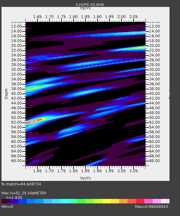
| Estimated Moho Depth: |
51.25 km |
| Estimated Crust Vp/Vs: |
1.63 |
| Assumed Crust Vp: |
4.73 km/s |
| Estimated Crust Vs: |
2.893 km/s |
| Estimated Crust Poisson's Ratio: |
0.20 |
|
| Radial Match: |
94.649734 % |
| Radial Bump: |
390 |
| Transverse Match: |
88.96677 % |
| Transverse Bump: |
400 |
| SOD ConfigId: |
3744 |
| Insert Time: |
2010-03-01 23:32:55.743 +0000 |
| GWidth: |
2.5 |
| Max Bumps: |
400 |
| Tol: |
0.001 |
|
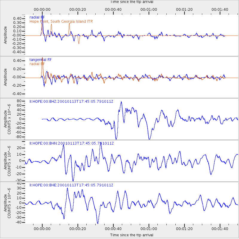
Signal To Noise
| Channel | StoN | STA | LTA |
| II:HOPE:00:BHN:20010113T17:45:05.791011Z | 0.8765247 | 1.8279984E-6 | 2.085507E-6 |
| II:HOPE:00:BHE:20010113T17:45:05.791011Z | 1.0692939 | 1.7014877E-6 | 1.5912256E-6 |
| II:HOPE:00:BHZ:20010113T17:45:05.791011Z | 1.3845092 | 4.313142E-6 | 3.1152858E-6 |
| Arrivals |
| Ps | 7.0 SECOND |
| PpPs | 28 SECOND |
| PsPs/PpSs | 35 SECOND |


