You are here: Home > Network List > II - Global Seismograph Network (GSN - IRIS/IDA) Stations List
> Station HOPE Hope Point, South Georgia Island > Earthquake Result Viewer
HOPE Hope Point, South Georgia Island - Earthquake Result Viewer
| Earthquake location: |
Near Coast Of Northern Chile |
| Earthquake latitude/longitude: |
-27.5/-70.6 |
| Earthquake time(UTC): |
2002/04/18 (108) 16:08:36 GMT |
| Earthquake Depth: |
62 km |
| Earthquake Magnitude: |
6.2 MB, 6.7 MW, 6.6 MW |
| Earthquake Catalog/Contributor: |
WHDF/NEIC |
|
| Network: |
II Global Seismograph Network (GSN - IRIS/IDA) |
| Station: |
HOPE Hope Point, South Georgia Island |
| Lat/Lon: |
54.28 S/36.49 W |
| Elevation: |
20 m |
|
| Distance: |
36.5 deg |
| Az: |
146.468 deg |
| Baz: |
303.22 deg |
| Ray Param: |
0.07646499 |
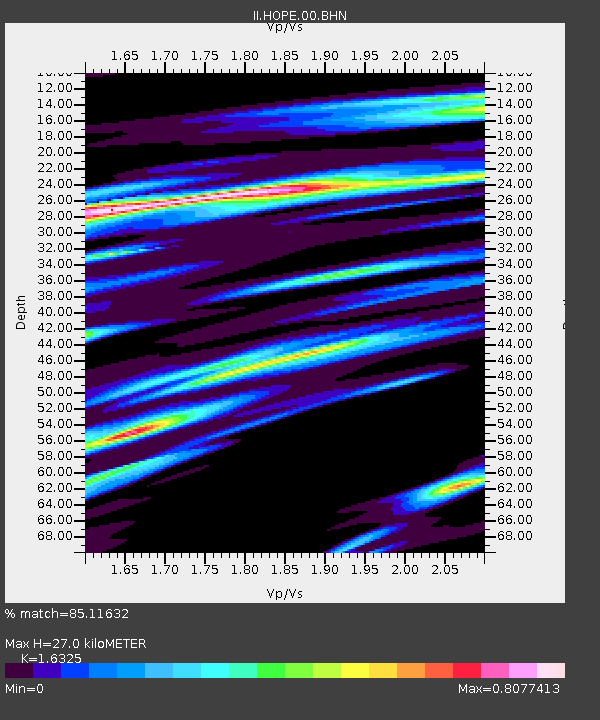
| Estimated Moho Depth: |
27.0 km |
| Estimated Crust Vp/Vs: |
1.63 |
| Assumed Crust Vp: |
4.73 km/s |
| Estimated Crust Vs: |
2.897 km/s |
| Estimated Crust Poisson's Ratio: |
0.20 |
|
| Radial Match: |
85.11632 % |
| Radial Bump: |
343 |
| Transverse Match: |
69.26234 % |
| Transverse Bump: |
400 |
| SOD ConfigId: |
20082 |
| Insert Time: |
2010-03-01 23:32:58.803 +0000 |
| GWidth: |
2.5 |
| Max Bumps: |
400 |
| Tol: |
0.001 |
|
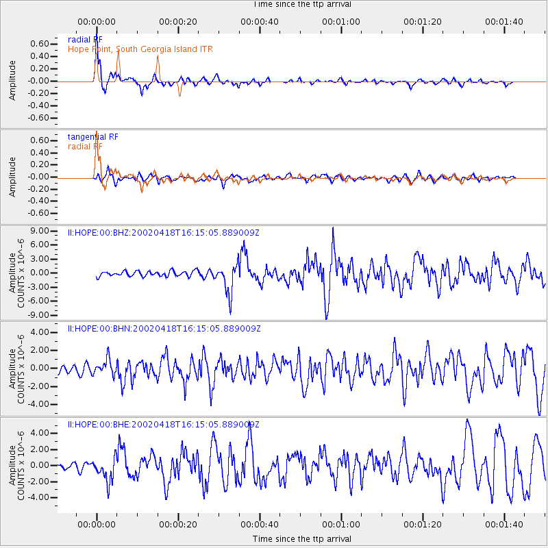
Signal To Noise
| Channel | StoN | STA | LTA |
| II:HOPE:00:BHN:20020418T16:15:05.889009Z | 1.6890883 | 8.8993033E-7 | 5.268702E-7 |
| II:HOPE:00:BHE:20020418T16:15:05.889009Z | 3.1265016 | 1.5559626E-6 | 4.976689E-7 |
| II:HOPE:00:BHZ:20020418T16:15:05.889009Z | 5.9357924 | 3.2136063E-6 | 5.413947E-7 |
| Arrivals |
| Ps | 3.8 SECOND |
| PpPs | 14 SECOND |
| PsPs/PpSs | 18 SECOND |


