You are here: Home > Network List > II - Global Seismograph Network (GSN - IRIS/IDA) Stations List
> Station HOPE Hope Point, South Georgia Island > Earthquake Result Viewer
HOPE Hope Point, South Georgia Island - Earthquake Result Viewer
| Earthquake location: |
Northern Peru |
| Earthquake latitude/longitude: |
-5.7/-76.4 |
| Earthquake time(UTC): |
2005/09/26 (269) 01:55:37 GMT |
| Earthquake Depth: |
115 km |
| Earthquake Magnitude: |
6.7 MB, 7.5 MW, 7.5 MW |
| Earthquake Catalog/Contributor: |
WHDF/NEIC |
|
| Network: |
II Global Seismograph Network (GSN - IRIS/IDA) |
| Station: |
HOPE Hope Point, South Georgia Island |
| Lat/Lon: |
54.28 S/36.49 W |
| Elevation: |
20 m |
|
| Distance: |
58.2 deg |
| Az: |
153.722 deg |
| Baz: |
311.29 deg |
| Ray Param: |
0.062666364 |
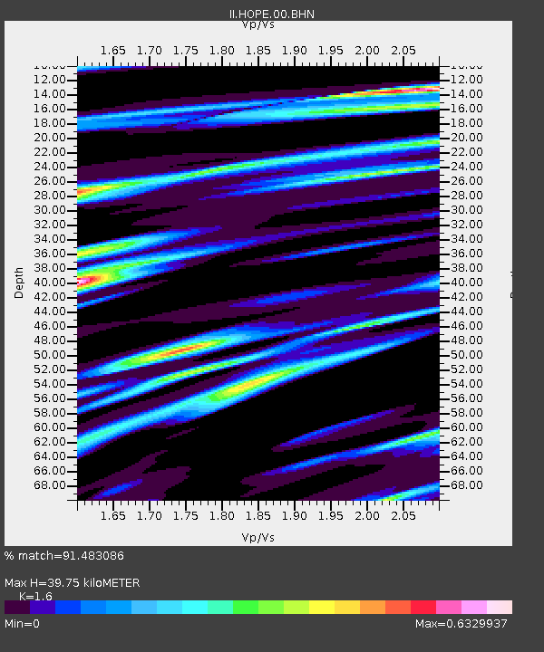
| Estimated Moho Depth: |
39.75 km |
| Estimated Crust Vp/Vs: |
1.60 |
| Assumed Crust Vp: |
4.73 km/s |
| Estimated Crust Vs: |
2.956 km/s |
| Estimated Crust Poisson's Ratio: |
0.18 |
|
| Radial Match: |
91.483086 % |
| Radial Bump: |
400 |
| Transverse Match: |
90.80062 % |
| Transverse Bump: |
400 |
| SOD ConfigId: |
2475 |
| Insert Time: |
2010-03-01 23:33:00.711 +0000 |
| GWidth: |
2.5 |
| Max Bumps: |
400 |
| Tol: |
0.001 |
|
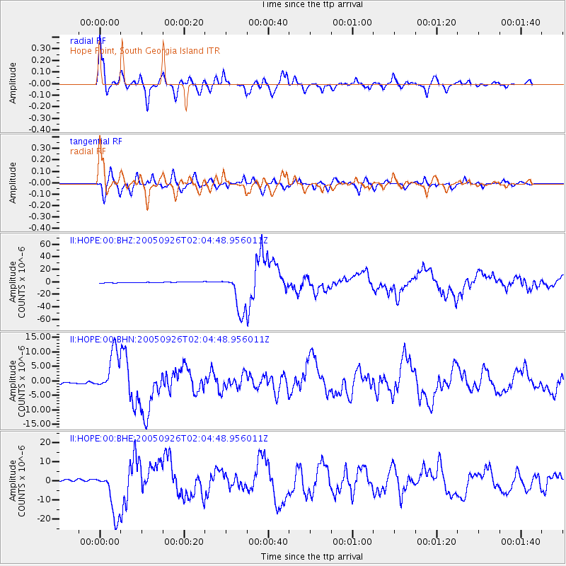
Signal To Noise
| Channel | StoN | STA | LTA |
| II:HOPE:00:BHN:20050926T02:04:48.956011Z | 20.038343 | 7.3849405E-6 | 3.685405E-7 |
| II:HOPE:00:BHE:20050926T02:04:48.956011Z | 27.63892 | 1.2619715E-5 | 4.5659215E-7 |
| II:HOPE:00:BHZ:20050926T02:04:48.956011Z | 50.45283 | 3.3279066E-5 | 6.596075E-7 |
| Arrivals |
| Ps | 5.2 SECOND |
| PpPs | 21 SECOND |
| PsPs/PpSs | 26 SECOND |


