You are here: Home > Network List > AZ - ANZA Regional Network Stations List
> Station RRSP RRSP, CA, USA > Earthquake Result Viewer
RRSP RRSP, CA, USA - Earthquake Result Viewer
| Earthquake location: |
Volcano Islands, Japan Region |
| Earthquake latitude/longitude: |
24.4/142.6 |
| Earthquake time(UTC): |
2014/06/29 (180) 05:56:31 GMT |
| Earthquake Depth: |
43 km |
| Earthquake Magnitude: |
6.2 MWP |
| Earthquake Catalog/Contributor: |
NEIC PDE/NEIC COMCAT |
|
| Network: |
AZ ANZA Regional Network |
| Station: |
RRSP RRSP, CA, USA |
| Lat/Lon: |
33.65 N/116.74 W |
| Elevation: |
1610 m |
|
| Distance: |
85.1 deg |
| Az: |
55.361 deg |
| Baz: |
295.938 deg |
| Ray Param: |
0.044954382 |
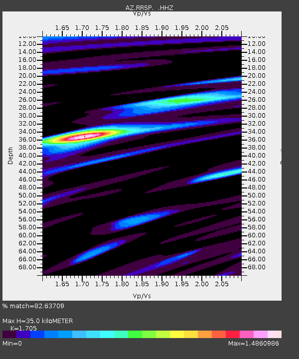
| Estimated Moho Depth: |
35.0 km |
| Estimated Crust Vp/Vs: |
1.71 |
| Assumed Crust Vp: |
6.264 km/s |
| Estimated Crust Vs: |
3.674 km/s |
| Estimated Crust Poisson's Ratio: |
0.24 |
|
| Radial Match: |
82.63709 % |
| Radial Bump: |
400 |
| Transverse Match: |
86.13305 % |
| Transverse Bump: |
400 |
| SOD ConfigId: |
751272 |
| Insert Time: |
2014-07-13 06:18:16.566 +0000 |
| GWidth: |
2.5 |
| Max Bumps: |
400 |
| Tol: |
0.001 |
|

Signal To Noise
| Channel | StoN | STA | LTA |
| AZ:RRSP: :HHZ:20140629T06:08:31.55897Z | 11.933041 | 1.5361552E-6 | 1.2873124E-7 |
| AZ:RRSP: :HHN:20140629T06:08:31.55897Z | 2.7467647 | 4.479041E-7 | 1.6306606E-7 |
| AZ:RRSP: :HHE:20140629T06:08:31.55897Z | 3.8610003 | 4.2963376E-7 | 1.1127525E-7 |
| Arrivals |
| Ps | 4.0 SECOND |
| PpPs | 15 SECOND |
| PsPs/PpSs | 19 SECOND |


