You are here: Home > Network List > II - Global Seismograph Network (GSN - IRIS/IDA) Stations List
> Station HOPE Hope Point, South Georgia Island > Earthquake Result Viewer
HOPE Hope Point, South Georgia Island - Earthquake Result Viewer

| Earthquake location: |
Southeast Indian Ridge |
| Earthquake latitude/longitude: |
-45.2/96.9 |
| Earthquake time(UTC): |
2005/10/29 (302) 04:05:56 GMT |
| Earthquake Depth: |
8.0 km |
| Earthquake Magnitude: |
6.1 MB, 6.2 MS, 6.5 MW, 6.4 MW |
| Earthquake Catalog/Contributor: |
WHDF/NEIC |
|
| Network: |
II Global Seismograph Network (GSN - IRIS/IDA) |
| Station: |
HOPE Hope Point, South Georgia Island |
| Lat/Lon: |
54.28 S/36.49 W |
| Elevation: |
20 m |
|
| Distance: |
73.2 deg |
| Az: |
206.425 deg |
| Baz: |
147.556 deg |
| Ray Param: |
0.053136244 |
| Estimated Moho Depth: |
31.0 km |
| Estimated Crust Vp/Vs: |
1.69 |
| Assumed Crust Vp: |
4.73 km/s |
| Estimated Crust Vs: |
2.803 km/s |
| Estimated Crust Poisson's Ratio: |
0.23 |
|
| Radial Match: |
88.5604 % |
| Radial Bump: |
305 |
| Transverse Match: |
76.69578 % |
| Transverse Bump: |
400 |
| SOD ConfigId: |
2500 |
| Insert Time: |
2010-03-01 23:33:04.226 +0000 |
| GWidth: |
2.5 |
| Max Bumps: |
400 |
| Tol: |
0.001 |
|
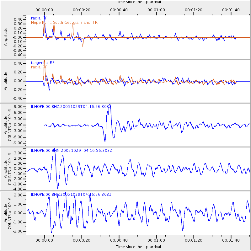
Signal To Noise
| Channel | StoN | STA | LTA |
| II:HOPE:00:BHN:20051029T04:16:56.303Z | 4.0586634 | 1.3726443E-6 | 3.382011E-7 |
| II:HOPE:00:BHE:20051029T04:16:56.303Z | 3.3494844 | 1.1998013E-6 | 3.582048E-7 |
| II:HOPE:00:BHZ:20051029T04:16:56.303Z | 14.5137 | 4.732219E-6 | 3.260519E-7 |
| Arrivals |
| Ps | 4.6 SECOND |
| PpPs | 17 SECOND |
| PsPs/PpSs | 22 SECOND |


