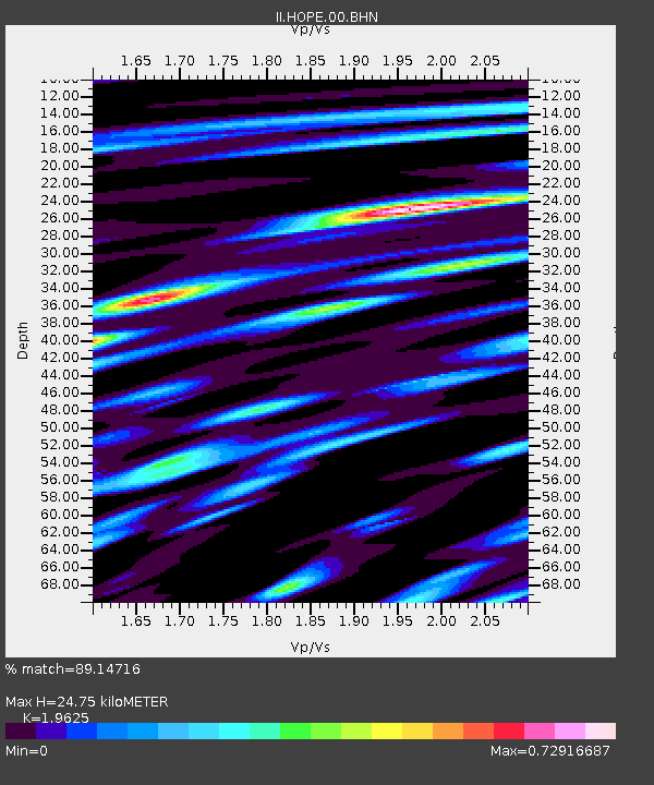
HOPE Hope Point, South Georgia Island - Earthquake Result Viewer

Earthquake location: Near Coast Of Northern Chile
Earthquake latitude/longitude: -23.9/-70.2
Earthquake time(UTC): 1998/01/30 (030) 12:16:08 GMT
Earthquake Depth: 42 km
Earthquake Magnitude: 6.3 MB, 6.5 MS, 7.0 UNKNOWN, 6.7 ME
Earthquake Catalog/Contributor: WHDF/NEIC
Network: II Global Seismograph Network (GSN - IRIS/IDA)
Station: HOPE Hope Point, South Georgia Island
Lat/Lon: 54.28 S/36.49 W
Elevation: 20 m
Distance: 39.4 deg
Az: 149.141 deg
Baz: 306.816 deg
Ray Param: 0.07491552
Estimated Moho Depth: 24.75 km
Estimated Crust Vp/Vs: 1.96
Assumed Crust Vp: 4.73 km/s
Estimated Crust Vs: 2.41 km/s
Estimated Crust Poisson's Ratio: 0.32
Radial Match: 89.14716 %
Radial Bump: 400
Transverse Match: 49.751377 %
Transverse Bump: 400
SOD ConfigId: 6273
Insert Time: 2010-03-01 23:33:11.206 +0000
GWidth: 2.5
Max Bumps: 400
Tol: 0.001

Signal To Noise

ChannelStoNSTALTA
II:HOPE:00:BHN:19980130T12:23:03.829004Z2.20197321.8853739E-68.5622014E-7
II:HOPE:00:BHE:19980130T12:23:03.82699Z2.71422582.1783449E-68.0256586E-7
II:HOPE:00:BHZ:19980130T12:23:03.826013Z6.8115565.1015195E-67.489507E-7
Arrivals
Ps5.2 SECOND
PpPs15 SECOND
PsPs/PpSs20 SECOND