You are here: Home > Network List > II - Global Seismograph Network (GSN - IRIS/IDA) Stations List
> Station HOPE Hope Point, South Georgia Island > Earthquake Result Viewer
HOPE Hope Point, South Georgia Island - Earthquake Result Viewer
| Earthquake location: |
Kermadec Islands Region |
| Earthquake latitude/longitude: |
-31.0/180.0 |
| Earthquake time(UTC): |
2007/09/25 (268) 05:16:01 GMT |
| Earthquake Depth: |
417 km |
| Earthquake Magnitude: |
6.2 MW, 5.2 MB, 6.2 MW |
| Earthquake Catalog/Contributor: |
WHDF/NEIC |
|
| Network: |
II Global Seismograph Network (GSN - IRIS/IDA) |
| Station: |
HOPE Hope Point, South Georgia Island |
| Lat/Lon: |
54.28 S/36.49 W |
| Elevation: |
20 m |
|
| Distance: |
89.4 deg |
| Az: |
159.593 deg |
| Baz: |
210.718 deg |
| Ray Param: |
0.04164073 |
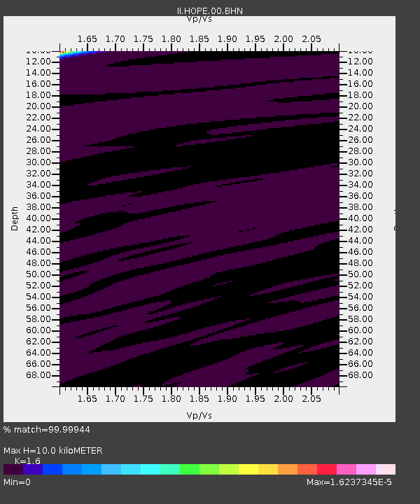
| Estimated Moho Depth: |
10.0 km |
| Estimated Crust Vp/Vs: |
1.60 |
| Assumed Crust Vp: |
4.73 km/s |
| Estimated Crust Vs: |
2.956 km/s |
| Estimated Crust Poisson's Ratio: |
0.18 |
|
| Radial Match: |
99.99944 % |
| Radial Bump: |
2 |
| Transverse Match: |
99.99585 % |
| Transverse Bump: |
2 |
| SOD ConfigId: |
2564 |
| Insert Time: |
2010-03-01 23:33:25.310 +0000 |
| GWidth: |
2.5 |
| Max Bumps: |
400 |
| Tol: |
0.001 |
|
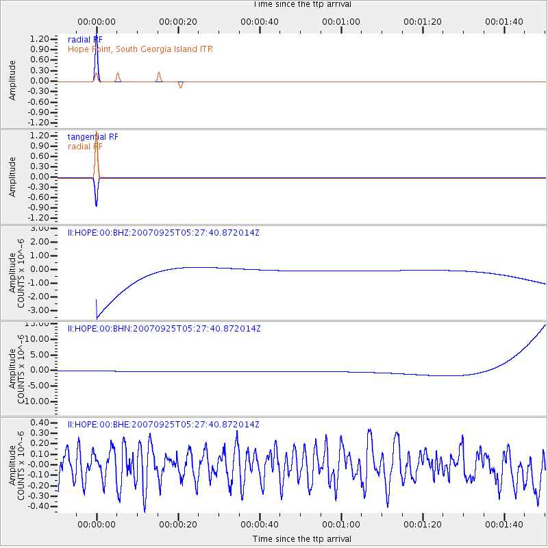
Signal To Noise
| Channel | StoN | STA | LTA |
| II:HOPE:00:BHN:20070925T05:27:40.872014Z | 0.9114868 | 1.1304493E-6 | 1.2402256E-6 |
| II:HOPE:00:BHE:20070925T05:27:40.872014Z | 0.7595548 | 1.3146371E-7 | 1.7307994E-7 |
| II:HOPE:00:BHZ:20070925T05:27:40.872014Z | 0.9110013 | 1.0003318E-6 | 1.0980575E-6 |
| Arrivals |
| Ps | 1.3 SECOND |
| PpPs | 5.4 SECOND |
| PsPs/PpSs | 6.7 SECOND |


