You are here: Home > Network List > IW - Intermountain West Stations List
> Station IMW Indian Meadow, Wyoming, USA > Earthquake Result Viewer
IMW Indian Meadow, Wyoming, USA - Earthquake Result Viewer
| Earthquake location: |
Volcano Islands, Japan Region |
| Earthquake latitude/longitude: |
24.4/142.6 |
| Earthquake time(UTC): |
2014/06/29 (180) 05:56:31 GMT |
| Earthquake Depth: |
43 km |
| Earthquake Magnitude: |
6.2 MWP |
| Earthquake Catalog/Contributor: |
NEIC PDE/NEIC COMCAT |
|
| Network: |
IW Intermountain West |
| Station: |
IMW Indian Meadow, Wyoming, USA |
| Lat/Lon: |
43.90 N/110.94 W |
| Elevation: |
2646 m |
|
| Distance: |
84.4 deg |
| Az: |
44.149 deg |
| Baz: |
298.545 deg |
| Ray Param: |
0.04541716 |
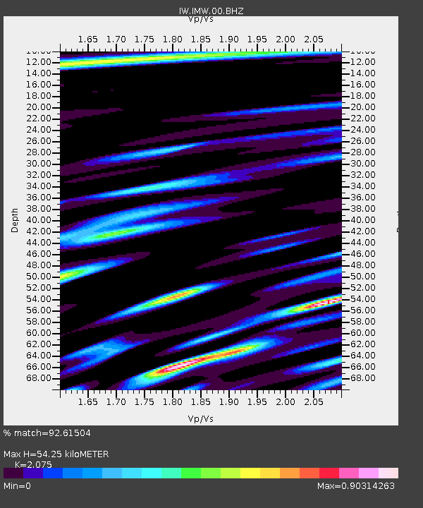
| Estimated Moho Depth: |
54.25 km |
| Estimated Crust Vp/Vs: |
2.08 |
| Assumed Crust Vp: |
6.207 km/s |
| Estimated Crust Vs: |
2.991 km/s |
| Estimated Crust Poisson's Ratio: |
0.35 |
|
| Radial Match: |
92.61504 % |
| Radial Bump: |
400 |
| Transverse Match: |
80.02568 % |
| Transverse Bump: |
400 |
| SOD ConfigId: |
751272 |
| Insert Time: |
2014-07-13 06:31:27.939 +0000 |
| GWidth: |
2.5 |
| Max Bumps: |
400 |
| Tol: |
0.001 |
|

Signal To Noise
| Channel | StoN | STA | LTA |
| IW:IMW:00:BHZ:20140629T06:08:28.339976Z | 7.207516 | 6.576836E-7 | 9.124968E-8 |
| IW:IMW:00:BH1:20140629T06:08:28.339976Z | 0.65550935 | 7.01351E-8 | 1.069933E-7 |
| IW:IMW:00:BH2:20140629T06:08:28.339976Z | 3.3363976 | 2.717179E-7 | 8.144051E-8 |
| Arrivals |
| Ps | 9.6 SECOND |
| PpPs | 26 SECOND |
| PsPs/PpSs | 36 SECOND |


