You are here: Home > Network List > KO - Kandilli Observatory Digital Broadband Seismic Network Stations List
> Station SIRT Sirnak-Turkey > Earthquake Result Viewer
SIRT Sirnak-Turkey - Earthquake Result Viewer
| Earthquake location: |
Volcano Islands, Japan Region |
| Earthquake latitude/longitude: |
24.4/142.6 |
| Earthquake time(UTC): |
2014/06/29 (180) 05:56:31 GMT |
| Earthquake Depth: |
43 km |
| Earthquake Magnitude: |
6.2 MWP |
| Earthquake Catalog/Contributor: |
NEIC PDE/NEIC COMCAT |
|
| Network: |
KO Kandilli Observatory Digital Broadband Seismic Network |
| Station: |
SIRT Sirnak-Turkey |
| Lat/Lon: |
37.50 N/42.44 E |
| Elevation: |
1038 m |
|
| Distance: |
83.0 deg |
| Az: |
307.938 deg |
| Baz: |
64.704 deg |
| Ray Param: |
0.046403363 |
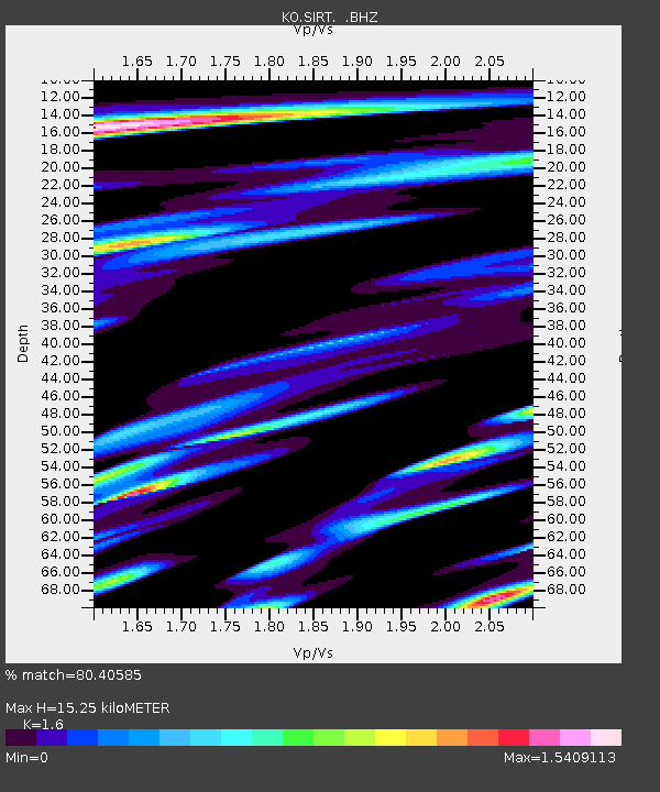
| Estimated Moho Depth: |
15.25 km |
| Estimated Crust Vp/Vs: |
1.60 |
| Assumed Crust Vp: |
6.482 km/s |
| Estimated Crust Vs: |
4.051 km/s |
| Estimated Crust Poisson's Ratio: |
0.18 |
|
| Radial Match: |
80.40585 % |
| Radial Bump: |
400 |
| Transverse Match: |
73.57997 % |
| Transverse Bump: |
400 |
| SOD ConfigId: |
751272 |
| Insert Time: |
2014-07-13 06:32:15.063 +0000 |
| GWidth: |
2.5 |
| Max Bumps: |
400 |
| Tol: |
0.001 |
|

Signal To Noise
| Channel | StoN | STA | LTA |
| KO:SIRT: :BHZ:20140629T06:08:21.21998Z | 6.810402 | 2.792535E-6 | 4.100397E-7 |
| KO:SIRT: :BHN:20140629T06:08:21.21998Z | 1.5323571 | 1.0660883E-6 | 6.957179E-7 |
| KO:SIRT: :BHE:20140629T06:08:21.21998Z | 1.7525474 | 1.9617446E-6 | 1.1193675E-6 |
| Arrivals |
| Ps | 1.5 SECOND |
| PpPs | 5.9 SECOND |
| PsPs/PpSs | 7.4 SECOND |


