You are here: Home > Network List > II - Global Seismograph Network (GSN - IRIS/IDA) Stations List
> Station HOPE Hope Point, South Georgia Island > Earthquake Result Viewer
HOPE Hope Point, South Georgia Island - Earthquake Result Viewer
| Earthquake location: |
Balleny Islands Region |
| Earthquake latitude/longitude: |
-62.7/155.7 |
| Earthquake time(UTC): |
2007/07/26 (207) 18:12:39 GMT |
| Earthquake Depth: |
10 km |
| Earthquake Magnitude: |
5.7 MW, 5.1 MS, 5.2 MB |
| Earthquake Catalog/Contributor: |
WHDF/NEIC |
|
| Network: |
II Global Seismograph Network (GSN - IRIS/IDA) |
| Station: |
HOPE Hope Point, South Georgia Island |
| Lat/Lon: |
54.28 S/36.49 W |
| Elevation: |
20 m |
|
| Distance: |
63.0 deg |
| Az: |
172.007 deg |
| Baz: |
186.279 deg |
| Ray Param: |
0.05987916 |
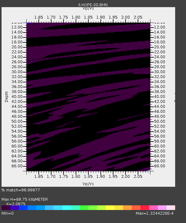
| Estimated Moho Depth: |
69.75 km |
| Estimated Crust Vp/Vs: |
2.10 |
| Assumed Crust Vp: |
4.73 km/s |
| Estimated Crust Vs: |
2.255 km/s |
| Estimated Crust Poisson's Ratio: |
0.35 |
|
| Radial Match: |
99.99977 % |
| Radial Bump: |
2 |
| Transverse Match: |
98.75796 % |
| Transverse Bump: |
47 |
| SOD ConfigId: |
2564 |
| Insert Time: |
2010-03-01 23:33:28.398 +0000 |
| GWidth: |
2.5 |
| Max Bumps: |
400 |
| Tol: |
0.001 |
|
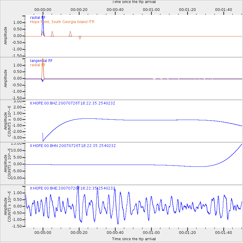
Signal To Noise
| Channel | StoN | STA | LTA |
| II:HOPE:00:BHN:20070726T18:22:35.254023Z | 0.9104019 | 1.1278697E-6 | 1.2388701E-6 |
| II:HOPE:00:BHE:20070726T18:22:35.254023Z | 0.98798084 | 5.56916E-7 | 5.636911E-7 |
| II:HOPE:00:BHZ:20070726T18:22:35.254023Z | 0.91109437 | 1.0002473E-6 | 1.0978525E-6 |
| Arrivals |
| Ps | 17 SECOND |
| PpPs | 45 SECOND |
| PsPs/PpSs | 61 SECOND |


