You are here: Home > Network List > PB - Plate Boundary Observatory Borehole Seismic Network Stations List
> Station B081 keenwi081bcs2006, Anza, CA, USA > Earthquake Result Viewer
B081 keenwi081bcs2006, Anza, CA, USA - Earthquake Result Viewer
| Earthquake location: |
Volcano Islands, Japan Region |
| Earthquake latitude/longitude: |
24.4/142.6 |
| Earthquake time(UTC): |
2014/06/29 (180) 05:56:31 GMT |
| Earthquake Depth: |
43 km |
| Earthquake Magnitude: |
6.2 MWP |
| Earthquake Catalog/Contributor: |
NEIC PDE/NEIC COMCAT |
|
| Network: |
PB Plate Boundary Observatory Borehole Seismic Network |
| Station: |
B081 keenwi081bcs2006, Anza, CA, USA |
| Lat/Lon: |
33.71 N/116.71 W |
| Elevation: |
1467 m |
|
| Distance: |
85.1 deg |
| Az: |
55.298 deg |
| Baz: |
295.947 deg |
| Ray Param: |
0.044959486 |
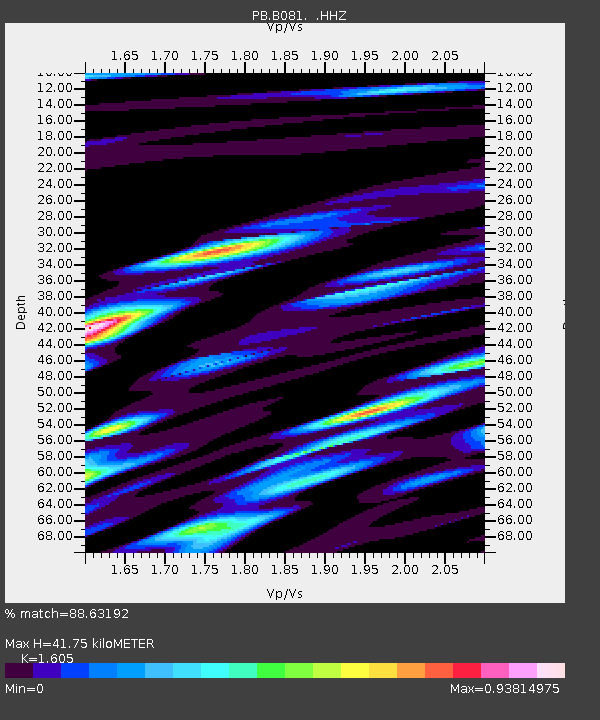
| Estimated Moho Depth: |
41.75 km |
| Estimated Crust Vp/Vs: |
1.61 |
| Assumed Crust Vp: |
6.264 km/s |
| Estimated Crust Vs: |
3.903 km/s |
| Estimated Crust Poisson's Ratio: |
0.18 |
|
| Radial Match: |
88.63192 % |
| Radial Bump: |
400 |
| Transverse Match: |
73.05803 % |
| Transverse Bump: |
400 |
| SOD ConfigId: |
751272 |
| Insert Time: |
2014-07-13 06:38:08.117 +0000 |
| GWidth: |
2.5 |
| Max Bumps: |
400 |
| Tol: |
0.001 |
|

Signal To Noise
| Channel | StoN | STA | LTA |
| PB:B081: :HHZ:20140629T06:08:31.523997Z | 14.716224 | 2.9918823E-8 | 2.0330504E-9 |
| PB:B081: :HH1:20140629T06:08:31.523997Z | 1.0049309 | 1.0413281E-9 | 1.0362188E-9 |
| PB:B081: :HH2:20140629T06:08:31.523997Z | 6.477807 | 1.125206E-8 | 1.7370168E-9 |
| Arrivals |
| Ps | 4.1 SECOND |
| PpPs | 17 SECOND |
| PsPs/PpSs | 21 SECOND |


