You are here: Home > Network List > II - Global Seismograph Network (GSN - IRIS/IDA) Stations List
> Station HOPE Hope Point, South Georgia Island > Earthquake Result Viewer
HOPE Hope Point, South Georgia Island - Earthquake Result Viewer
| Earthquake location: |
Pacific-Antarctic Ridge |
| Earthquake latitude/longitude: |
-55.1/-129.4 |
| Earthquake time(UTC): |
2007/07/21 (202) 20:40:53 GMT |
| Earthquake Depth: |
10 km |
| Earthquake Magnitude: |
5.7 MW, 5.2 MS, 5.1 MB |
| Earthquake Catalog/Contributor: |
WHDF/NEIC |
|
| Network: |
II Global Seismograph Network (GSN - IRIS/IDA) |
| Station: |
HOPE Hope Point, South Georgia Island |
| Lat/Lon: |
54.28 S/36.49 W |
| Elevation: |
20 m |
|
| Distance: |
49.8 deg |
| Az: |
129.932 deg |
| Baz: |
228.744 deg |
| Ray Param: |
0.068476856 |
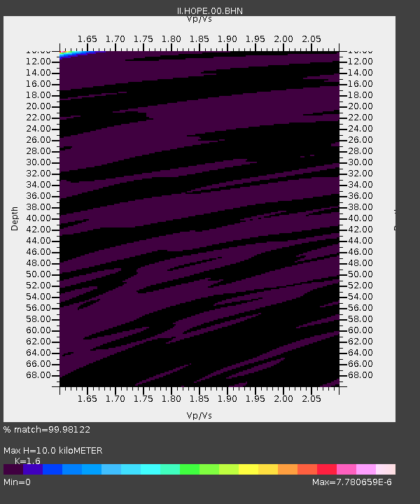
| Estimated Moho Depth: |
10.0 km |
| Estimated Crust Vp/Vs: |
1.60 |
| Assumed Crust Vp: |
4.73 km/s |
| Estimated Crust Vs: |
2.956 km/s |
| Estimated Crust Poisson's Ratio: |
0.18 |
|
| Radial Match: |
99.98122 % |
| Radial Bump: |
2 |
| Transverse Match: |
99.98892 % |
| Transverse Bump: |
2 |
| SOD ConfigId: |
2564 |
| Insert Time: |
2010-03-01 23:33:35.201 +0000 |
| GWidth: |
2.5 |
| Max Bumps: |
400 |
| Tol: |
0.001 |
|
Signal To Noise
| Channel | StoN | STA | LTA |
| II:HOPE:00:BHN:20070721T20:49:15.611014Z | 0.9106485 | 1.1289951E-6 | 1.2397704E-6 |
| II:HOPE:00:BHE:20070721T20:49:15.611014Z | 0.56956464 | 2.9106198E-7 | 5.1102535E-7 |
| II:HOPE:00:BHZ:20070721T20:49:15.611014Z | 0.9115909 | 1.0007294E-6 | 1.0977835E-6 |
| Arrivals |
| Ps | 1.3 SECOND |
| PpPs | 5.3 SECOND |
| PsPs/PpSs | 6.6 SECOND |


