You are here: Home > Network List > II - Global Seismograph Network (GSN - IRIS/IDA) Stations List
> Station HOPE Hope Point, South Georgia Island > Earthquake Result Viewer
HOPE Hope Point, South Georgia Island - Earthquake Result Viewer
| Earthquake location: |
South Of Fiji Islands |
| Earthquake latitude/longitude: |
-26.2/-177.7 |
| Earthquake time(UTC): |
2007/07/17 (198) 09:39:27 GMT |
| Earthquake Depth: |
10 km |
| Earthquake Magnitude: |
5.7 MB, 6.0 MS, 6.1 MW, 6.0 MW |
| Earthquake Catalog/Contributor: |
WHDF/NEIC |
|
| Network: |
II Global Seismograph Network (GSN - IRIS/IDA) |
| Station: |
HOPE Hope Point, South Georgia Island |
| Lat/Lon: |
54.28 S/36.49 W |
| Elevation: |
20 m |
|
| Distance: |
93.2 deg |
| Az: |
158.437 deg |
| Baz: |
214.27 deg |
| Ray Param: |
0.04131631 |
| Estimated Moho Depth: |
10.0 km |
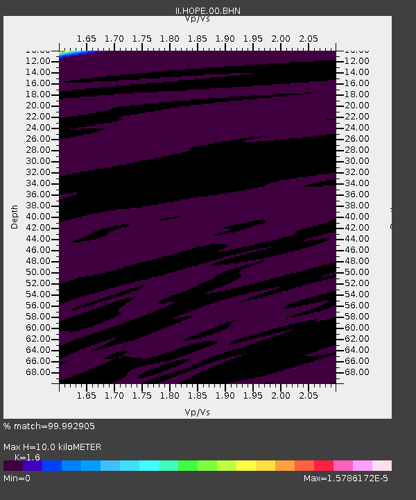
| Estimated Crust Vp/Vs: |
1.60 |
| Assumed Crust Vp: |
4.73 km/s |
| Estimated Crust Vs: |
2.956 km/s |
| Estimated Crust Poisson's Ratio: |
0.18 |
|
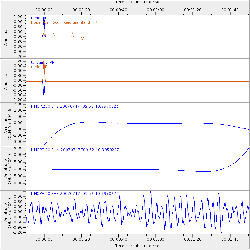
| Radial Match: |
99.992905 % |
| Radial Bump: |
2 |
| Transverse Match: |
99.967125 % |
| Transverse Bump: |
2 |
| SOD ConfigId: |
2564 |
| Insert Time: |
2010-03-01 23:33:39.672 +0000 |
| GWidth: |
2.5 |
| Max Bumps: |
400 |
| Tol: |
0.001 |
|
Signal To Noise
| Channel | StoN | STA | LTA |
| II:HOPE:00:BHN:20070717T09:52:10.395022Z | 0.9110138 | 1.1275305E-6 | 1.2376656E-6 |
| II:HOPE:00:BHE:20070717T09:52:10.395022Z | 0.5655953 | 2.874822E-7 | 5.082825E-7 |
| II:HOPE:00:BHZ:20070717T09:52:10.395022Z | 0.9116467 | 1.0001062E-6 | 1.0970326E-6 |
| Arrivals |
| Ps | 1.3 SECOND |
| PpPs | 5.4 SECOND |
| PsPs/PpSs | 6.7 SECOND |


