You are here: Home > Network List > TA - USArray Transportable Network (new EarthScope stations) Stations List
> Station D46A Sault St. Marie, ON, CAN > Earthquake Result Viewer
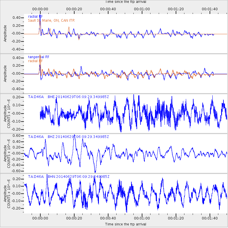
D46A Sault St. Marie, ON, CAN - Earthquake Result Viewer
*The percent match for this event was below the threshold and hence no stack was calculated.
| Earthquake location: |
Volcano Islands, Japan Region |
| Earthquake latitude/longitude: |
24.4/142.6 |
| Earthquake time(UTC): |
2014/06/29 (180) 05:56:31 GMT |
| Earthquake Depth: |
43 km |
| Earthquake Magnitude: |
6.2 MWP |
| Earthquake Catalog/Contributor: |
NEIC PDE/NEIC COMCAT |
|
| Network: |
TA USArray Transportable Network (new EarthScope stations) |
| Station: |
D46A Sault St. Marie, ON, CAN |
| Lat/Lon: |
46.89 N/84.04 W |
| Elevation: |
353 m |
|
| Distance: |
97.5 deg |
| Az: |
30.187 deg |
| Baz: |
318.054 deg |
| Ray Param: |
$rayparam |
*The percent match for this event was below the threshold and hence was not used in the summary stack. |
|
| Radial Match: |
69.60652 % |
| Radial Bump: |
400 |
| Transverse Match: |
64.76051 % |
| Transverse Bump: |
400 |
| SOD ConfigId: |
751272 |
| Insert Time: |
2014-07-13 06:43:00.102 +0000 |
| GWidth: |
2.5 |
| Max Bumps: |
400 |
| Tol: |
0.001 |
|
Signal To Noise
| Channel | StoN | STA | LTA |
| TA:D46A: :BHZ:20140629T06:09:29.349985Z | 2.8440797 | 1.9793339E-7 | 6.9594876E-8 |
| TA:D46A: :BHN:20140629T06:09:29.349985Z | 1.1973314 | 1.03218525E-7 | 8.6207145E-8 |
| TA:D46A: :BHE:20140629T06:09:29.349985Z | 1.3140266 | 8.269583E-8 | 6.293315E-8 |
| Arrivals |
| Ps | |
| PpPs | |
| PsPs/PpSs | |


