You are here: Home > Network List > TA - USArray Transportable Network (new EarthScope stations) Stations List
> Station Q61A Milford, DE, USA > Earthquake Result Viewer
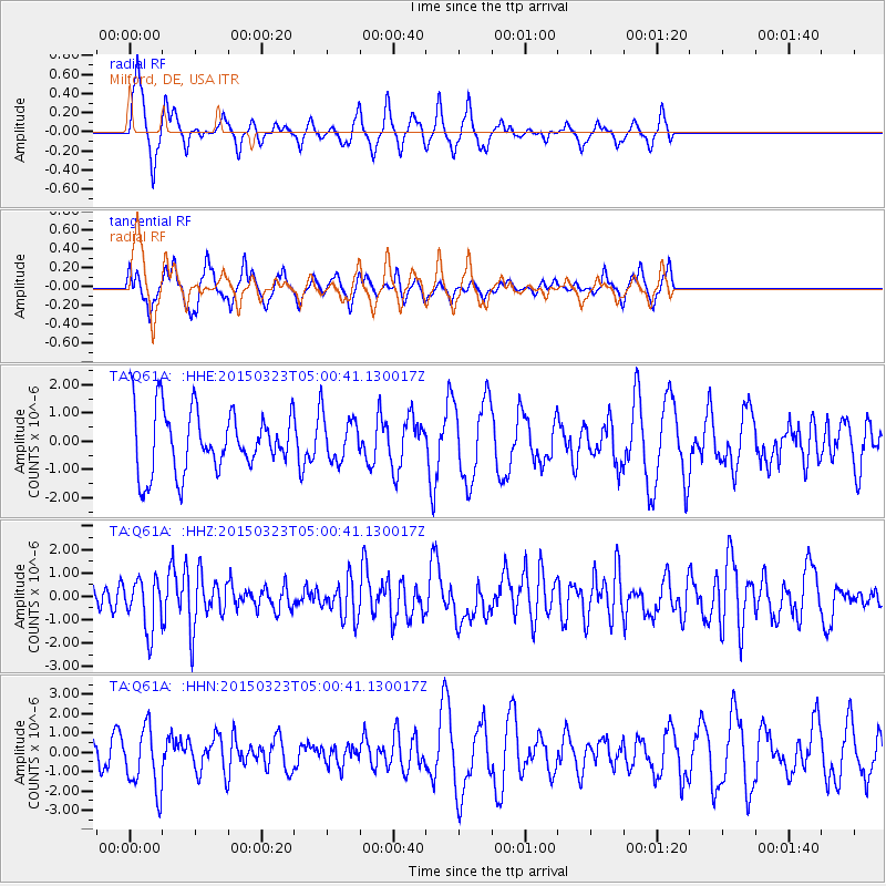
Q61A Milford, DE, USA - Earthquake Result Viewer
*The percent match for this event was below the threshold and hence no stack was calculated.
| Earthquake location: |
Northern Chile |
| Earthquake latitude/longitude: |
-18.4/-69.4 |
| Earthquake time(UTC): |
2015/03/23 (082) 04:51:37 GMT |
| Earthquake Depth: |
128 km |
| Earthquake Magnitude: |
6.1 MWP, 6.1 MO |
| Earthquake Catalog/Contributor: |
NEIC PDE/NEIC ALERT |
|
| Network: |
TA USArray Transportable Network (new EarthScope stations) |
| Station: |
Q61A Milford, DE, USA |
| Lat/Lon: |
38.88 N/75.33 W |
| Elevation: |
5.0 m |
|
| Distance: |
57.3 deg |
| Az: |
354.471 deg |
| Baz: |
173.27 deg |
| Ray Param: |
$rayparam |
*The percent match for this event was below the threshold and hence was not used in the summary stack. |
|
| Radial Match: |
67.99174 % |
| Radial Bump: |
294 |
| Transverse Match: |
53.70828 % |
| Transverse Bump: |
294 |
| SOD ConfigId: |
7422571 |
| Insert Time: |
2019-04-17 21:27:31.682 +0000 |
| GWidth: |
2.5 |
| Max Bumps: |
400 |
| Tol: |
0.001 |
|
Signal To Noise
| Channel | StoN | STA | LTA |
| TA:Q61A: :HHZ:20150323T05:00:41.130017Z | 3.1251857 | 1.0729082E-6 | 3.4331018E-7 |
| TA:Q61A: :HHN:20150323T05:00:41.130017Z | 1.5775919 | 1.6051238E-6 | 1.0174517E-6 |
| TA:Q61A: :HHE:20150323T05:00:41.130017Z | 0.79329056 | 8.6540956E-7 | 1.0909112E-6 |
| Arrivals |
| Ps | |
| PpPs | |
| PsPs/PpSs | |


