You are here: Home > Network List > TA - USArray Transportable Network (new EarthScope stations) Stations List
> Station G05D Wamic, OR, USA > Earthquake Result Viewer
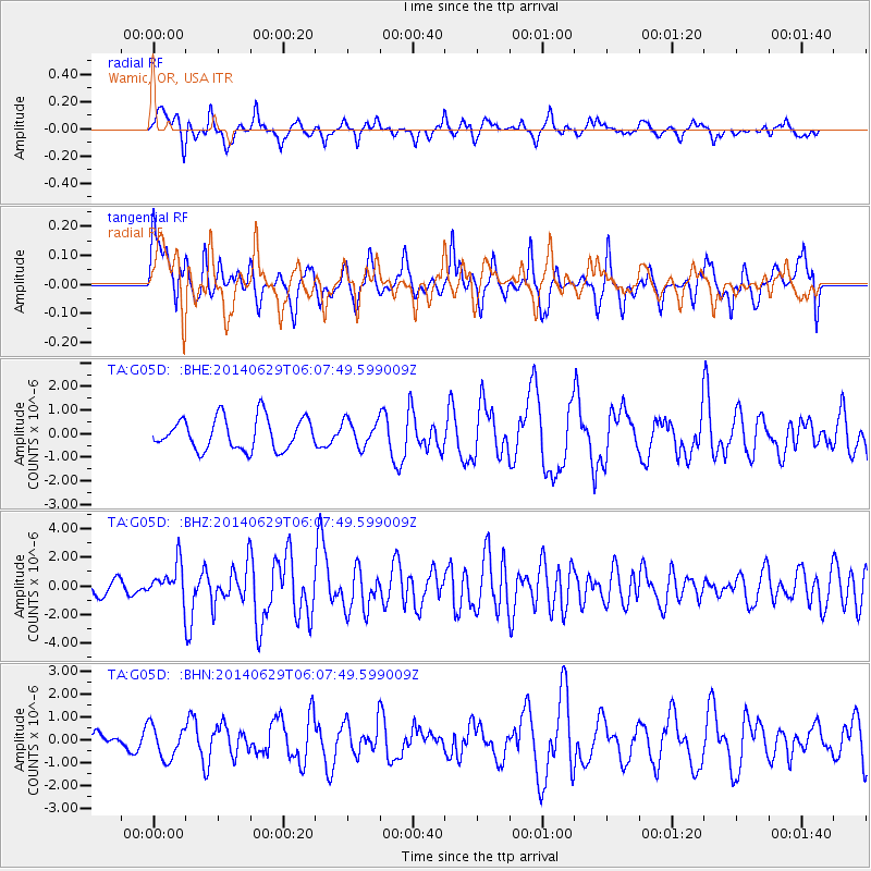
G05D Wamic, OR, USA - Earthquake Result Viewer
*The percent match for this event was below the threshold and hence no stack was calculated.
| Earthquake location: |
Volcano Islands, Japan Region |
| Earthquake latitude/longitude: |
24.4/142.6 |
| Earthquake time(UTC): |
2014/06/29 (180) 05:56:31 GMT |
| Earthquake Depth: |
43 km |
| Earthquake Magnitude: |
6.2 MWP |
| Earthquake Catalog/Contributor: |
NEIC PDE/NEIC COMCAT |
|
| Network: |
TA USArray Transportable Network (new EarthScope stations) |
| Station: |
G05D Wamic, OR, USA |
| Lat/Lon: |
45.24 N/121.32 W |
| Elevation: |
592 m |
|
| Distance: |
77.2 deg |
| Az: |
46.099 deg |
| Baz: |
291.589 deg |
| Ray Param: |
$rayparam |
*The percent match for this event was below the threshold and hence was not used in the summary stack. |
|
| Radial Match: |
54.453743 % |
| Radial Bump: |
380 |
| Transverse Match: |
55.72055 % |
| Transverse Bump: |
400 |
| SOD ConfigId: |
751272 |
| Insert Time: |
2014-07-13 06:43:20.798 +0000 |
| GWidth: |
2.5 |
| Max Bumps: |
400 |
| Tol: |
0.001 |
|
Signal To Noise
| Channel | StoN | STA | LTA |
| TA:G05D: :BHZ:20140629T06:07:49.599009Z | 3.1266708 | 1.2168844E-6 | 3.8919487E-7 |
| TA:G05D: :BHN:20140629T06:07:49.599009Z | 0.81378865 | 7.2324053E-7 | 8.8873264E-7 |
| TA:G05D: :BHE:20140629T06:07:49.599009Z | 0.8137685 | 5.461694E-7 | 6.7116065E-7 |
| Arrivals |
| Ps | |
| PpPs | |
| PsPs/PpSs | |


