You are here: Home > Network List > TA - USArray Transportable Network (new EarthScope stations) Stations List
> Station R55A Marlinton, WV, USA > Earthquake Result Viewer
R55A Marlinton, WV, USA - Earthquake Result Viewer
| Earthquake location: |
Northern Chile |
| Earthquake latitude/longitude: |
-18.4/-69.4 |
| Earthquake time(UTC): |
2015/03/23 (082) 04:51:37 GMT |
| Earthquake Depth: |
128 km |
| Earthquake Magnitude: |
6.1 MWP, 6.1 MO |
| Earthquake Catalog/Contributor: |
NEIC PDE/NEIC ALERT |
|
| Network: |
TA USArray Transportable Network (new EarthScope stations) |
| Station: |
R55A Marlinton, WV, USA |
| Lat/Lon: |
38.28 N/80.12 W |
| Elevation: |
833 m |
|
| Distance: |
57.3 deg |
| Az: |
349.95 deg |
| Baz: |
167.849 deg |
| Ray Param: |
0.06318063 |
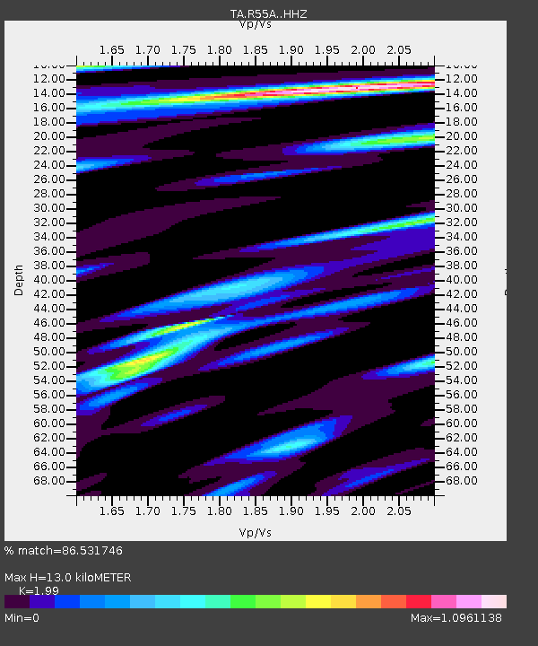
| Estimated Moho Depth: |
13.0 km |
| Estimated Crust Vp/Vs: |
1.99 |
| Assumed Crust Vp: |
6.207 km/s |
| Estimated Crust Vs: |
3.119 km/s |
| Estimated Crust Poisson's Ratio: |
0.33 |
|
| Radial Match: |
86.531746 % |
| Radial Bump: |
400 |
| Transverse Match: |
71.456665 % |
| Transverse Bump: |
400 |
| SOD ConfigId: |
7422571 |
| Insert Time: |
2019-04-17 21:27:33.778 +0000 |
| GWidth: |
2.5 |
| Max Bumps: |
400 |
| Tol: |
0.001 |
|

Signal To Noise
| Channel | StoN | STA | LTA |
| TA:R55A: :HHZ:20150323T05:00:41.419995Z | 7.2378626 | 1.1400447E-6 | 1.5751122E-7 |
| TA:R55A: :HHN:20150323T05:00:41.419995Z | 4.4028416 | 5.939228E-7 | 1.3489534E-7 |
| TA:R55A: :HHE:20150323T05:00:41.419995Z | 1.0777754 | 1.6796315E-7 | 1.5584246E-7 |
| Arrivals |
| Ps | 2.2 SECOND |
| PpPs | 6.0 SECOND |
| PsPs/PpSs | 8.2 SECOND |


