You are here: Home > Network List > II - Global Seismograph Network (GSN - IRIS/IDA) Stations List
> Station HOPE Hope Point, South Georgia Island > Earthquake Result Viewer
HOPE Hope Point, South Georgia Island - Earthquake Result Viewer
| Earthquake location: |
Southern Pacific Ocean |
| Earthquake latitude/longitude: |
-36.2/-100.2 |
| Earthquake time(UTC): |
2007/06/14 (165) 13:37:40 GMT |
| Earthquake Depth: |
10 km |
| Earthquake Magnitude: |
5.9 MW, 5.4 MS, 5.4 MB, 5.8 MW |
| Earthquake Catalog/Contributor: |
WHDF/NEIC |
|
| Network: |
II Global Seismograph Network (GSN - IRIS/IDA) |
| Station: |
HOPE Hope Point, South Georgia Island |
| Lat/Lon: |
54.28 S/36.49 W |
| Elevation: |
20 m |
|
| Distance: |
46.6 deg |
| Az: |
133.698 deg |
| Baz: |
265.722 deg |
| Ray Param: |
0.070529856 |
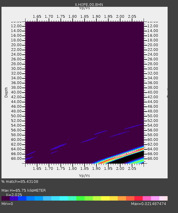
| Estimated Moho Depth: |
65.75 km |
| Estimated Crust Vp/Vs: |
2.03 |
| Assumed Crust Vp: |
4.73 km/s |
| Estimated Crust Vs: |
2.336 km/s |
| Estimated Crust Poisson's Ratio: |
0.34 |
|
| Radial Match: |
85.43108 % |
| Radial Bump: |
214 |
| Transverse Match: |
99.999146 % |
| Transverse Bump: |
2 |
| SOD ConfigId: |
2564 |
| Insert Time: |
2010-03-01 23:33:43.254 +0000 |
| GWidth: |
2.5 |
| Max Bumps: |
400 |
| Tol: |
0.001 |
|
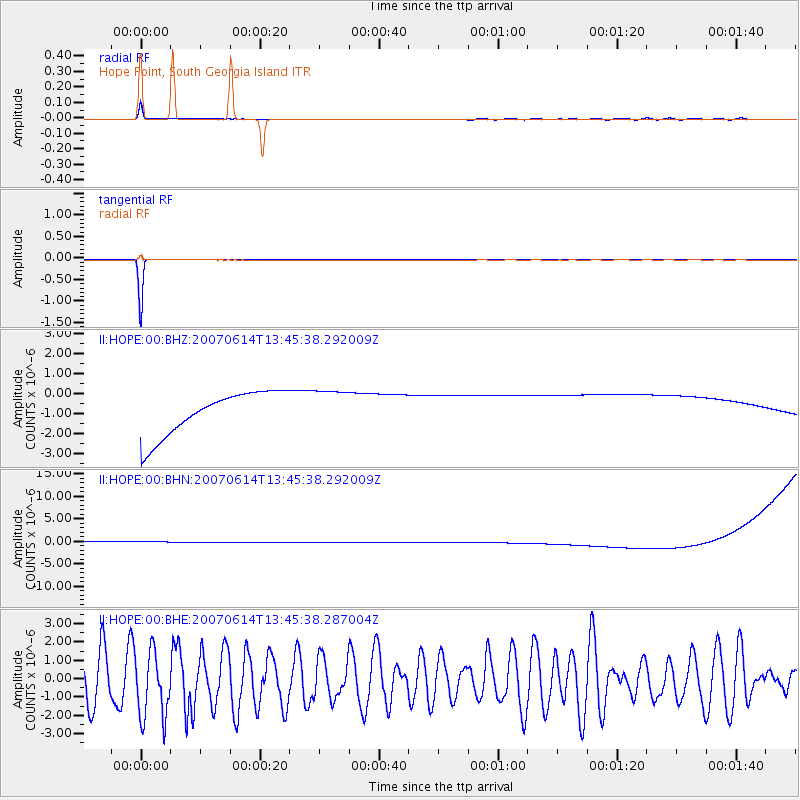
Signal To Noise
| Channel | StoN | STA | LTA |
| II:HOPE:00:BHN:20070614T13:45:38.292009Z | 0.91244733 | 1.131061E-6 | 1.2395905E-6 |
| II:HOPE:00:BHE:20070614T13:45:38.287004Z | 1.385696 | 1.9061847E-6 | 1.3756153E-6 |
| II:HOPE:00:BHZ:20070614T13:45:38.292009Z | 0.91103536 | 1.0004063E-6 | 1.0980982E-6 |
| Arrivals |
| Ps | 15 SECOND |
| PpPs | 41 SECOND |
| PsPs/PpSs | 56 SECOND |


