You are here: Home > Network List > TA - USArray Transportable Network (new EarthScope stations) Stations List
> Station SUSD Miller, SD, USA > Earthquake Result Viewer
SUSD Miller, SD, USA - Earthquake Result Viewer
| Earthquake location: |
Northern Chile |
| Earthquake latitude/longitude: |
-18.4/-69.4 |
| Earthquake time(UTC): |
2015/03/23 (082) 04:51:37 GMT |
| Earthquake Depth: |
128 km |
| Earthquake Magnitude: |
6.1 MWP, 6.1 MO |
| Earthquake Catalog/Contributor: |
NEIC PDE/NEIC ALERT |
|
| Network: |
TA USArray Transportable Network (new EarthScope stations) |
| Station: |
SUSD Miller, SD, USA |
| Lat/Lon: |
44.44 N/98.96 W |
| Elevation: |
520 m |
|
| Distance: |
68.2 deg |
| Az: |
337.601 deg |
| Baz: |
149.668 deg |
| Ray Param: |
0.056141272 |
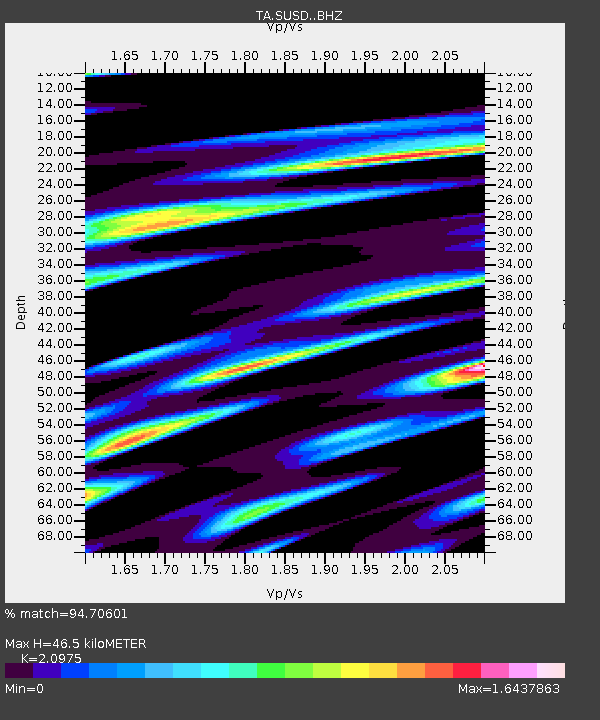
| Estimated Moho Depth: |
46.5 km |
| Estimated Crust Vp/Vs: |
2.10 |
| Assumed Crust Vp: |
6.53 km/s |
| Estimated Crust Vs: |
3.113 km/s |
| Estimated Crust Poisson's Ratio: |
0.35 |
|
| Radial Match: |
94.70601 % |
| Radial Bump: |
400 |
| Transverse Match: |
80.72914 % |
| Transverse Bump: |
400 |
| SOD ConfigId: |
7422571 |
| Insert Time: |
2019-04-17 21:27:46.431 +0000 |
| GWidth: |
2.5 |
| Max Bumps: |
400 |
| Tol: |
0.001 |
|

Signal To Noise
| Channel | StoN | STA | LTA |
| TA:SUSD: :BHZ:20150323T05:01:53.450024Z | 10.565266 | 1.93003E-6 | 1.826769E-7 |
| TA:SUSD: :BHN:20150323T05:01:53.450024Z | 5.66094 | 1.7254758E-6 | 3.0480376E-7 |
| TA:SUSD: :BHE:20150323T05:01:53.450024Z | 3.5131588 | 8.1394063E-7 | 2.3168343E-7 |
| Arrivals |
| Ps | 8.1 SECOND |
| PpPs | 21 SECOND |
| PsPs/PpSs | 29 SECOND |


