You are here: Home > Network List > TA - USArray Transportable Network (new EarthScope stations) Stations List
> Station TPFO Pinon Flats, CA, USA > Earthquake Result Viewer
TPFO Pinon Flats, CA, USA - Earthquake Result Viewer
| Earthquake location: |
Northern Chile |
| Earthquake latitude/longitude: |
-18.4/-69.4 |
| Earthquake time(UTC): |
2015/03/23 (082) 04:51:37 GMT |
| Earthquake Depth: |
128 km |
| Earthquake Magnitude: |
6.1 MWP, 6.1 MO |
| Earthquake Catalog/Contributor: |
NEIC PDE/NEIC ALERT |
|
| Network: |
TA USArray Transportable Network (new EarthScope stations) |
| Station: |
TPFO Pinon Flats, CA, USA |
| Lat/Lon: |
33.61 N/116.45 W |
| Elevation: |
1275 m |
|
| Distance: |
68.5 deg |
| Az: |
318.936 deg |
| Baz: |
131.651 deg |
| Ray Param: |
0.055912804 |
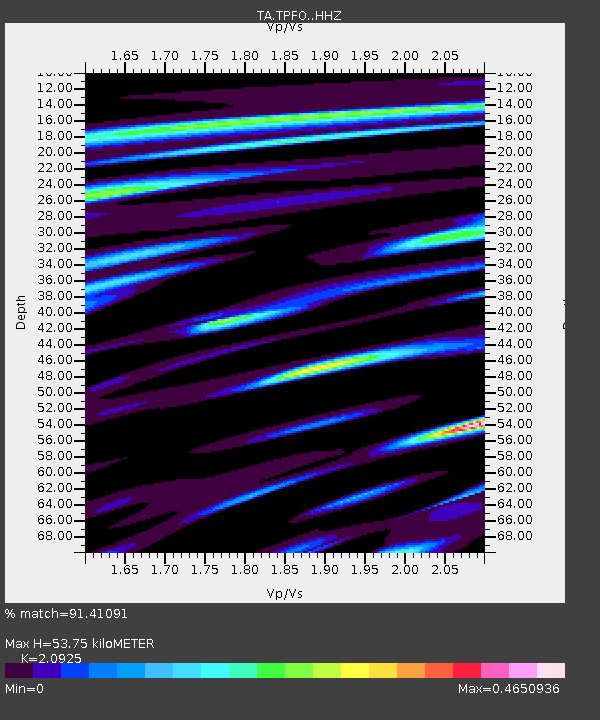
| Estimated Moho Depth: |
53.75 km |
| Estimated Crust Vp/Vs: |
2.09 |
| Assumed Crust Vp: |
6.264 km/s |
| Estimated Crust Vs: |
2.993 km/s |
| Estimated Crust Poisson's Ratio: |
0.35 |
|
| Radial Match: |
91.41091 % |
| Radial Bump: |
366 |
| Transverse Match: |
76.9601 % |
| Transverse Bump: |
400 |
| SOD ConfigId: |
7422571 |
| Insert Time: |
2019-04-17 21:27:52.305 +0000 |
| GWidth: |
2.5 |
| Max Bumps: |
400 |
| Tol: |
0.001 |
|
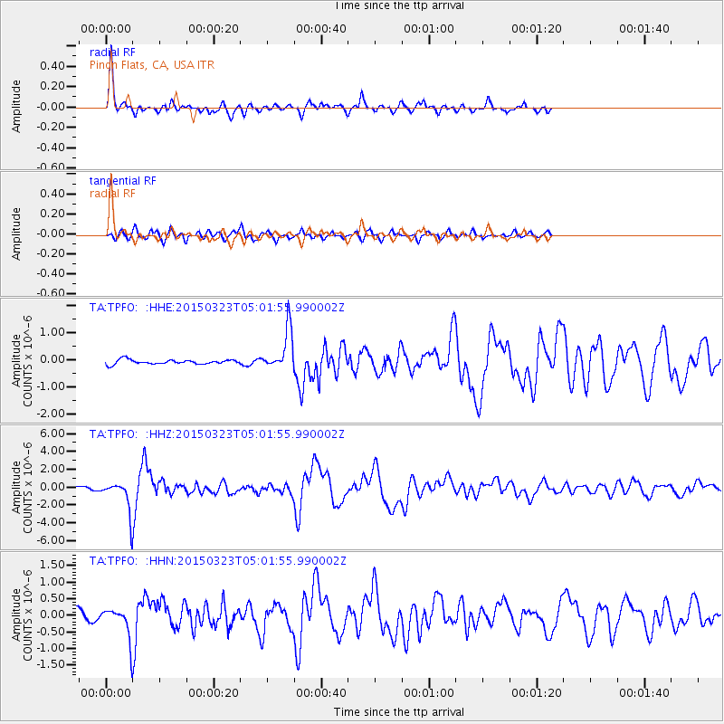
Signal To Noise
| Channel | StoN | STA | LTA |
| TA:TPFO: :HHZ:20150323T05:01:55.990002Z | 8.490029 | 1.7968123E-6 | 2.1163792E-7 |
| TA:TPFO: :HHN:20150323T05:01:55.990002Z | 3.1358008 | 4.889082E-7 | 1.5591174E-7 |
| TA:TPFO: :HHE:20150323T05:01:55.990002Z | 7.0409946 | 5.854673E-7 | 8.315122E-8 |
| Arrivals |
| Ps | 9.7 SECOND |
| PpPs | 26 SECOND |
| PsPs/PpSs | 35 SECOND |


