You are here: Home > Network List > II - Global Seismograph Network (GSN - IRIS/IDA) Stations List
> Station HOPE Hope Point, South Georgia Island > Earthquake Result Viewer
HOPE Hope Point, South Georgia Island - Earthquake Result Viewer
| Earthquake location: |
Mozambique |
| Earthquake latitude/longitude: |
-21.3/33.6 |
| Earthquake time(UTC): |
2006/02/22 (053) 22:19:07 GMT |
| Earthquake Depth: |
11 km |
| Earthquake Magnitude: |
6.5 MB, 7.5 MS, 7.0 MW, 7.0 MW |
| Earthquake Catalog/Contributor: |
WHDF/NEIC |
|
| Network: |
II Global Seismograph Network (GSN - IRIS/IDA) |
| Station: |
HOPE Hope Point, South Georgia Island |
| Lat/Lon: |
54.28 S/36.49 W |
| Elevation: |
20 m |
|
| Distance: |
61.4 deg |
| Az: |
218.907 deg |
| Baz: |
87.032 deg |
| Ray Param: |
0.06091607 |
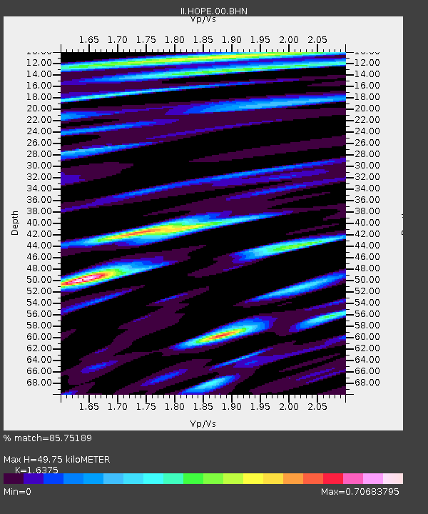
| Estimated Moho Depth: |
49.75 km |
| Estimated Crust Vp/Vs: |
1.64 |
| Assumed Crust Vp: |
4.73 km/s |
| Estimated Crust Vs: |
2.889 km/s |
| Estimated Crust Poisson's Ratio: |
0.20 |
|
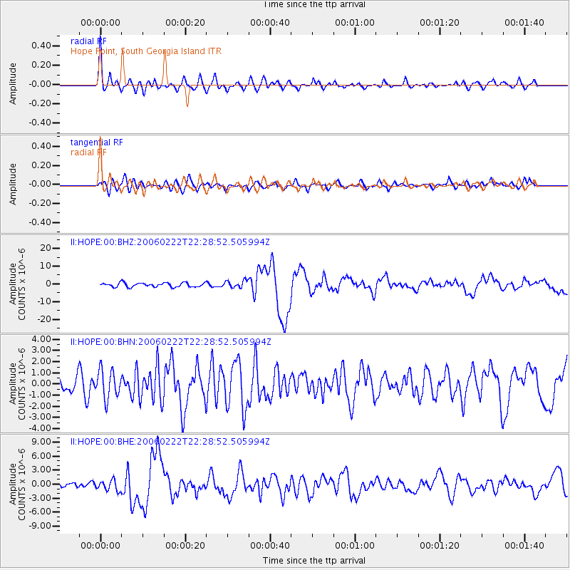
| Radial Match: |
85.75189 % |
| Radial Bump: |
400 |
| Transverse Match: |
70.50186 % |
| Transverse Bump: |
400 |
| SOD ConfigId: |
2669 |
| Insert Time: |
2010-03-01 23:33:51.035 +0000 |
| GWidth: |
2.5 |
| Max Bumps: |
400 |
| Tol: |
0.001 |
|
Signal To Noise
| Channel | StoN | STA | LTA |
| II:HOPE:00:BHN:20060222T22:28:52.505994Z | 1.8170893 | 1.291618E-6 | 7.10817E-7 |
| II:HOPE:00:BHE:20060222T22:28:52.505994Z | 2.0394967 | 1.1566533E-6 | 5.6712685E-7 |
| II:HOPE:00:BHZ:20060222T22:28:52.505994Z | 1.7865818 | 2.0620914E-6 | 1.1542105E-6 |
| Arrivals |
| Ps | 6.9 SECOND |
| PpPs | 27 SECOND |
| PsPs/PpSs | 34 SECOND |


