You are here: Home > Network List > II - Global Seismograph Network (GSN - IRIS/IDA) Stations List
> Station HOPE Hope Point, South Georgia Island > Earthquake Result Viewer
HOPE Hope Point, South Georgia Island - Earthquake Result Viewer
| Earthquake location: |
Jujuy Province, Argentina |
| Earthquake latitude/longitude: |
-23.5/-66.5 |
| Earthquake time(UTC): |
2000/05/12 (133) 18:43:18 GMT |
| Earthquake Depth: |
225 km |
| Earthquake Magnitude: |
6.2 MB, 7.2 MW, 7.1 MW |
| Earthquake Catalog/Contributor: |
WHDF/NEIC |
|
| Network: |
II Global Seismograph Network (GSN - IRIS/IDA) |
| Station: |
HOPE Hope Point, South Georgia Island |
| Lat/Lon: |
54.28 S/36.49 W |
| Elevation: |
20 m |
|
| Distance: |
38.0 deg |
| Az: |
151.598 deg |
| Baz: |
311.888 deg |
| Ray Param: |
0.0749432 |
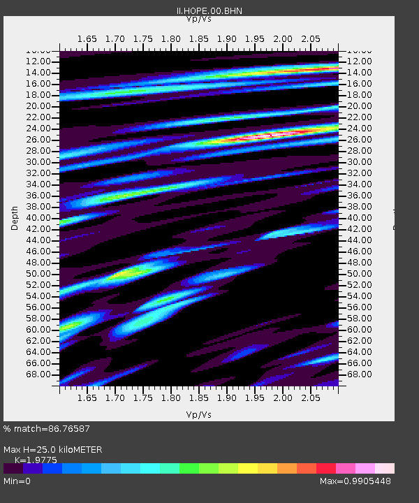
| Estimated Moho Depth: |
25.0 km |
| Estimated Crust Vp/Vs: |
1.98 |
| Assumed Crust Vp: |
4.73 km/s |
| Estimated Crust Vs: |
2.392 km/s |
| Estimated Crust Poisson's Ratio: |
0.33 |
|
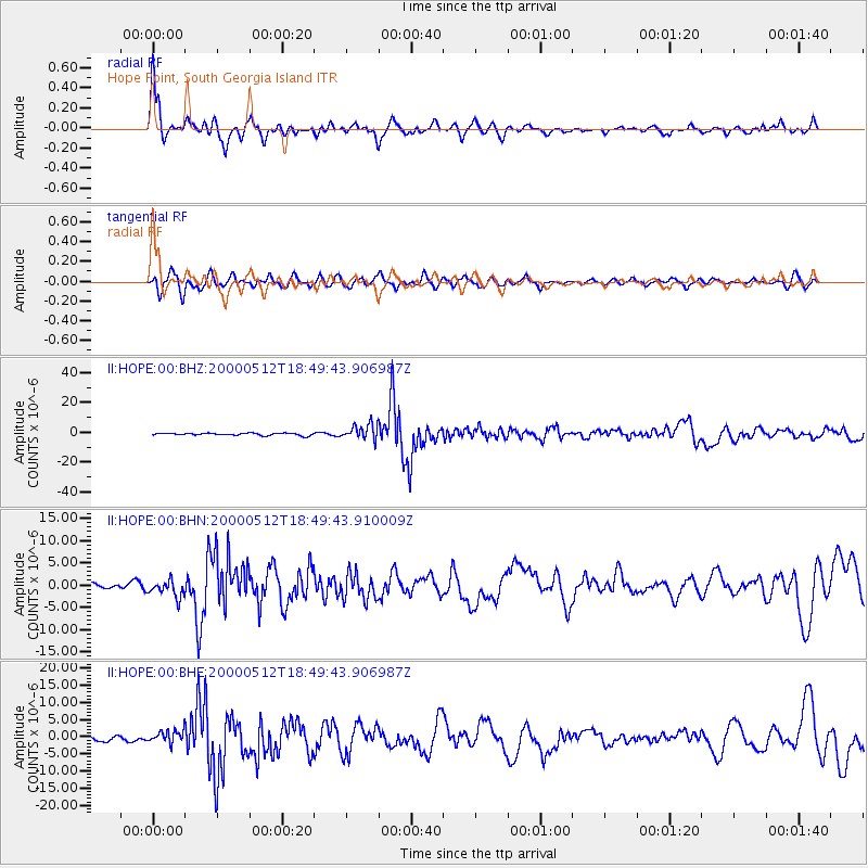
| Radial Match: |
86.76587 % |
| Radial Bump: |
400 |
| Transverse Match: |
81.516106 % |
| Transverse Bump: |
400 |
| SOD ConfigId: |
3744 |
| Insert Time: |
2010-03-01 23:33:52.592 +0000 |
| GWidth: |
2.5 |
| Max Bumps: |
400 |
| Tol: |
0.001 |
|
Signal To Noise
| Channel | StoN | STA | LTA |
| II:HOPE:00:BHN:20000512T18:49:43.910009Z | 2.765616 | 2.0310495E-6 | 7.3439315E-7 |
| II:HOPE:00:BHE:20000512T18:49:43.906987Z | 3.5965571 | 1.837415E-6 | 5.1088165E-7 |
| II:HOPE:00:BHZ:20000512T18:49:43.906987Z | 6.629036 | 5.070949E-6 | 7.6496025E-7 |
| Arrivals |
| Ps | 5.3 SECOND |
| PpPs | 15 SECOND |
| PsPs/PpSs | 21 SECOND |


