You are here: Home > Network List > II - Global Seismograph Network (GSN - IRIS/IDA) Stations List
> Station HOPE Hope Point, South Georgia Island > Earthquake Result Viewer
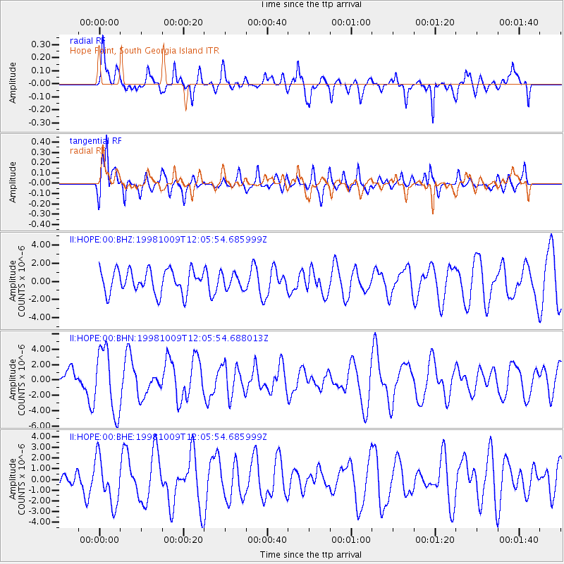
HOPE Hope Point, South Georgia Island - Earthquake Result Viewer
*The percent match for this event was below the threshold and hence no stack was calculated.
| Earthquake location: |
Near Coast Of Nicaragua |
| Earthquake latitude/longitude: |
11.3/-86.5 |
| Earthquake time(UTC): |
1998/10/09 (282) 11:54:36 GMT |
| Earthquake Depth: |
69 km |
| Earthquake Magnitude: |
5.5 MB, 5.7 MS, 6.0 UNKNOWN |
| Earthquake Catalog/Contributor: |
WHDF/NEIC |
|
| Network: |
II Global Seismograph Network (GSN - IRIS/IDA) |
| Station: |
HOPE Hope Point, South Georgia Island |
| Lat/Lon: |
54.28 S/36.49 W |
| Elevation: |
20 m |
|
| Distance: |
77.8 deg |
| Az: |
152.653 deg |
| Baz: |
309.791 deg |
| Ray Param: |
$rayparam |
*The percent match for this event was below the threshold and hence was not used in the summary stack. |
|
| Radial Match: |
65.44868 % |
| Radial Bump: |
400 |
| Transverse Match: |
63.75154 % |
| Transverse Bump: |
400 |
| SOD ConfigId: |
4480 |
| Insert Time: |
2010-03-01 23:34:08.149 +0000 |
| GWidth: |
2.5 |
| Max Bumps: |
400 |
| Tol: |
0.001 |
|
Signal To Noise
| Channel | StoN | STA | LTA |
| II:HOPE:00:BHN:19981009T12:05:54.688013Z | 2.6797533 | 4.19973E-6 | 1.5672077E-6 |
| II:HOPE:00:BHE:19981009T12:05:54.685999Z | 1.6028243 | 2.219011E-6 | 1.3844382E-6 |
| II:HOPE:00:BHZ:19981009T12:05:54.685999Z | 0.6636032 | 8.423014E-7 | 1.2692848E-6 |
| Arrivals |
| Ps | |
| PpPs | |
| PsPs/PpSs | |


