You are here: Home > Network List > UU - University of Utah Regional Network Stations List
> Station VRUT Veyo Road, Veyo, UT, USA > Earthquake Result Viewer
VRUT Veyo Road, Veyo, UT, USA - Earthquake Result Viewer
| Earthquake location: |
Volcano Islands, Japan Region |
| Earthquake latitude/longitude: |
24.4/142.6 |
| Earthquake time(UTC): |
2014/06/29 (180) 05:56:31 GMT |
| Earthquake Depth: |
43 km |
| Earthquake Magnitude: |
6.2 MWP |
| Earthquake Catalog/Contributor: |
NEIC PDE/NEIC COMCAT |
|
| Network: |
UU University of Utah Regional Network |
| Station: |
VRUT Veyo Road, Veyo, UT, USA |
| Lat/Lon: |
37.46 N/113.86 W |
| Elevation: |
1874 m |
|
| Distance: |
85.5 deg |
| Az: |
50.894 deg |
| Baz: |
297.241 deg |
| Ray Param: |
0.044666935 |
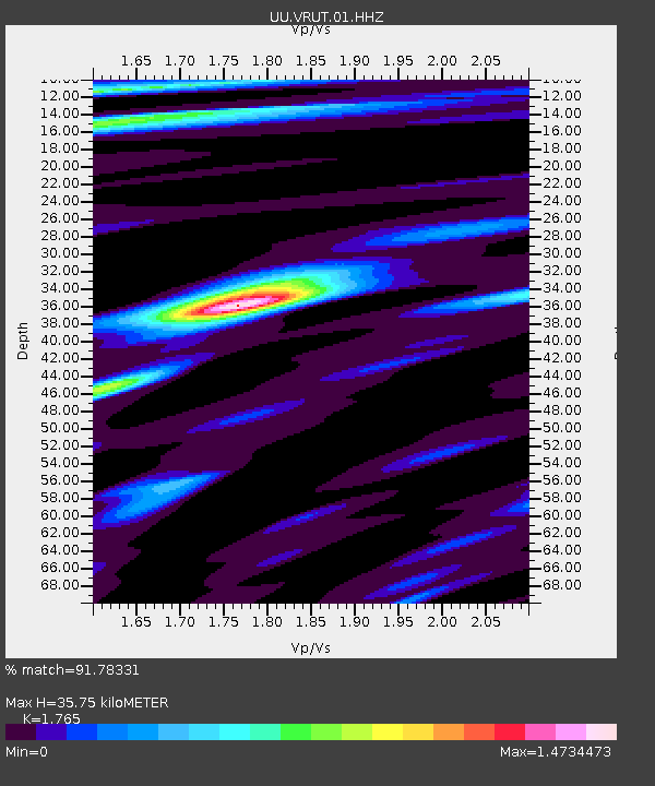
| Estimated Moho Depth: |
35.75 km |
| Estimated Crust Vp/Vs: |
1.76 |
| Assumed Crust Vp: |
6.194 km/s |
| Estimated Crust Vs: |
3.509 km/s |
| Estimated Crust Poisson's Ratio: |
0.26 |
|
| Radial Match: |
91.78331 % |
| Radial Bump: |
400 |
| Transverse Match: |
86.30622 % |
| Transverse Bump: |
400 |
| SOD ConfigId: |
751272 |
| Insert Time: |
2014-07-13 06:50:07.417 +0000 |
| GWidth: |
2.5 |
| Max Bumps: |
400 |
| Tol: |
0.001 |
|

Signal To Noise
| Channel | StoN | STA | LTA |
| UU:VRUT:01:HHZ:20140629T06:08:33.549998Z | 11.230503 | 2.6835624E-8 | 2.38953E-9 |
| UU:VRUT:01:HHN:20140629T06:08:33.549998Z | 4.606962 | 6.2991488E-9 | 1.3673107E-9 |
| UU:VRUT:01:HHE:20140629T06:08:33.549998Z | 4.106599 | 1.0081837E-8 | 2.4550335E-9 |
| Arrivals |
| Ps | 4.5 SECOND |
| PpPs | 16 SECOND |
| PsPs/PpSs | 20 SECOND |


