You are here: Home > Network List > CN - Canadian National Seismograph Network Stations List
> Station PAPH Port au Prince, Haiti, > Earthquake Result Viewer
PAPH Port au Prince, Haiti, - Earthquake Result Viewer
| Earthquake location: |
South Sandwich Islands Region |
| Earthquake latitude/longitude: |
-55.5/-28.5 |
| Earthquake time(UTC): |
2014/06/29 (180) 07:52:56 GMT |
| Earthquake Depth: |
16 km |
| Earthquake Magnitude: |
6.9 MWW, 7.2 MI |
| Earthquake Catalog/Contributor: |
NEIC PDE/NEIC COMCAT |
|
| Network: |
CN Canadian National Seismograph Network |
| Station: |
PAPH Port au Prince, Haiti, |
| Lat/Lon: |
18.52 N/72.30 W |
| Elevation: |
218 m |
|
| Distance: |
82.6 deg |
| Az: |
318.478 deg |
| Baz: |
156.58 deg |
| Ray Param: |
0.04679561 |
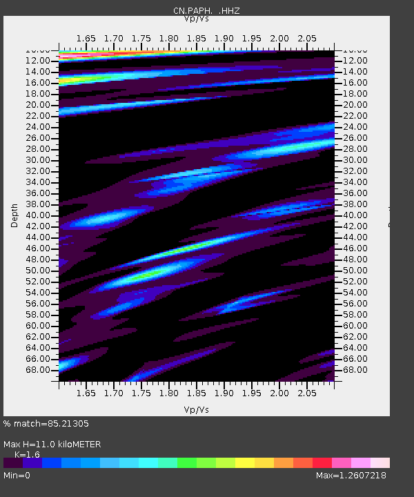
| Estimated Moho Depth: |
11.0 km |
| Estimated Crust Vp/Vs: |
1.60 |
| Assumed Crust Vp: |
5.14 km/s |
| Estimated Crust Vs: |
3.212 km/s |
| Estimated Crust Poisson's Ratio: |
0.18 |
|
| Radial Match: |
85.21305 % |
| Radial Bump: |
379 |
| Transverse Match: |
79.4872 % |
| Transverse Bump: |
400 |
| SOD ConfigId: |
751272 |
| Insert Time: |
2014-07-13 08:06:37.905 +0000 |
| GWidth: |
2.5 |
| Max Bumps: |
400 |
| Tol: |
0.001 |
|

Signal To Noise
| Channel | StoN | STA | LTA |
| CN:PAPH: :HHZ:20140629T08:04:47.329004Z | 5.403723 | 9.438188E-7 | 1.7466085E-7 |
| CN:PAPH: :HHN:20140629T08:04:47.329004Z | 2.2110794 | 3.0814206E-7 | 1.3936274E-7 |
| CN:PAPH: :HHE:20140629T08:04:47.329004Z | 1.6739572 | 2.183632E-7 | 1.304473E-7 |
| Arrivals |
| Ps | 1.3 SECOND |
| PpPs | 5.5 SECOND |
| PsPs/PpSs | 6.8 SECOND |


