You are here: Home > Network List > G - GEOSCOPE Stations List
> Station FDF Fort de France, Martinique France > Earthquake Result Viewer
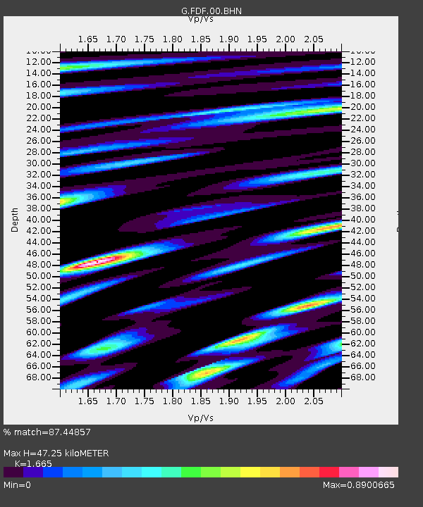
FDF Fort de France, Martinique France - Earthquake Result Viewer
| Earthquake location: |
South Sandwich Islands Region |
| Earthquake latitude/longitude: |
-55.5/-28.5 |
| Earthquake time(UTC): |
2014/06/29 (180) 07:52:56 GMT |
| Earthquake Depth: |
16 km |
| Earthquake Magnitude: |
6.9 MWW, 7.2 MI |
| Earthquake Catalog/Contributor: |
NEIC PDE/NEIC COMCAT |
|
| Network: |
G GEOSCOPE |
| Station: |
FDF Fort de France, Martinique France |
| Lat/Lon: |
14.73 N/61.14 W |
| Elevation: |
467 m |
|
| Distance: |
75.2 deg |
| Az: |
327.281 deg |
| Baz: |
161.469 deg |
| Ray Param: |
0.05181253 |
| Estimated Moho Depth: |
47.25 km |
| Estimated Crust Vp/Vs: |
1.66 |
| Assumed Crust Vp: |
5.88 km/s |
| Estimated Crust Vs: |
3.532 km/s |
| Estimated Crust Poisson's Ratio: |
0.22 |
|
| Radial Match: |
87.44857 % |
| Radial Bump: |
400 |
| Transverse Match: |
82.101746 % |
| Transverse Bump: |
400 |
| SOD ConfigId: |
751272 |
| Insert Time: |
2014-07-13 08:07:39.327 +0000 |
| GWidth: |
2.5 |
| Max Bumps: |
400 |
| Tol: |
0.001 |
|

Signal To Noise
| Channel | StoN | STA | LTA |
| G:FDF:00:BHZ:20140629T08:04:07.149988Z | 4.5337343 | 2.4968876E-6 | 5.5073536E-7 |
| G:FDF:00:BHN:20140629T08:04:07.149988Z | 1.4616203 | 1.1478942E-6 | 7.8535726E-7 |
| G:FDF:00:BHE:20140629T08:04:07.149988Z | 1.6100194 | 9.104465E-7 | 5.654879E-7 |
| Arrivals |
| Ps | 5.5 SECOND |
| PpPs | 21 SECOND |
| PsPs/PpSs | 26 SECOND |


