You are here: Home > Network List > G - GEOSCOPE Stations List
> Station TAM Tamanrasset, Algeria > Earthquake Result Viewer
TAM Tamanrasset, Algeria - Earthquake Result Viewer
| Earthquake location: |
South Sandwich Islands Region |
| Earthquake latitude/longitude: |
-55.5/-28.5 |
| Earthquake time(UTC): |
2014/06/29 (180) 07:52:56 GMT |
| Earthquake Depth: |
16 km |
| Earthquake Magnitude: |
6.9 MWW, 7.2 MI |
| Earthquake Catalog/Contributor: |
NEIC PDE/NEIC COMCAT |
|
| Network: |
G GEOSCOPE |
| Station: |
TAM Tamanrasset, Algeria |
| Lat/Lon: |
22.79 N/5.53 E |
| Elevation: |
1377 m |
|
| Distance: |
83.2 deg |
| Az: |
31.293 deg |
| Baz: |
198.675 deg |
| Ray Param: |
0.046354502 |
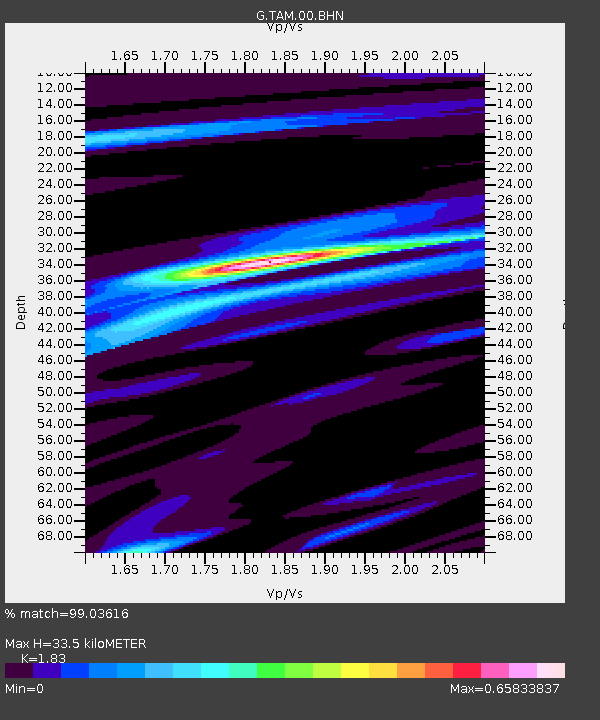
| Estimated Moho Depth: |
33.5 km |
| Estimated Crust Vp/Vs: |
1.83 |
| Assumed Crust Vp: |
6.61 km/s |
| Estimated Crust Vs: |
3.612 km/s |
| Estimated Crust Poisson's Ratio: |
0.29 |
|
| Radial Match: |
99.03616 % |
| Radial Bump: |
231 |
| Transverse Match: |
91.10075 % |
| Transverse Bump: |
400 |
| SOD ConfigId: |
751272 |
| Insert Time: |
2014-07-13 08:08:16.566 +0000 |
| GWidth: |
2.5 |
| Max Bumps: |
400 |
| Tol: |
0.001 |
|

Signal To Noise
| Channel | StoN | STA | LTA |
| G:TAM:00:BHZ:20140629T08:04:50.649011Z | 24.068405 | 1.8861194E-6 | 7.8364955E-8 |
| G:TAM:00:BHN:20140629T08:04:50.649011Z | 15.992325 | 6.95618E-7 | 4.349699E-8 |
| G:TAM:00:BHE:20140629T08:04:50.649011Z | 4.371807 | 2.4147616E-7 | 5.523486E-8 |
| Arrivals |
| Ps | 4.3 SECOND |
| PpPs | 14 SECOND |
| PsPs/PpSs | 18 SECOND |


