You are here: Home > Network List > X614 - Homestake Gold Mine Three dimensional Broadband Array Stations List
> Station B4850 4850 level Homestake mine - near shaft 6 > Earthquake Result Viewer
B4850 4850 level Homestake mine - near shaft 6 - Earthquake Result Viewer
| Earthquake location: |
Northern Chile |
| Earthquake latitude/longitude: |
-18.4/-69.4 |
| Earthquake time(UTC): |
2015/03/23 (082) 04:51:37 GMT |
| Earthquake Depth: |
128 km |
| Earthquake Magnitude: |
6.1 MWP, 6.1 MO |
| Earthquake Catalog/Contributor: |
NEIC PDE/NEIC ALERT |
|
| Network: |
X6 Homestake Gold Mine Three dimensional Broadband Array |
| Station: |
B4850 4850 level Homestake mine - near shaft 6 |
| Lat/Lon: |
44.35 N/103.76 W |
| Elevation: |
115 m |
|
| Distance: |
69.9 deg |
| Az: |
334.439 deg |
| Baz: |
145.188 deg |
| Ray Param: |
0.054978013 |
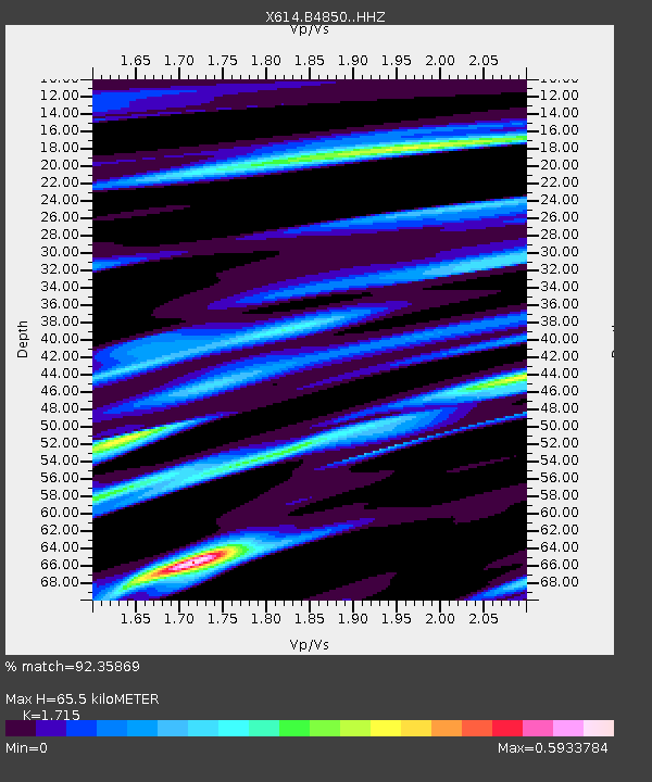
| Estimated Moho Depth: |
65.5 km |
| Estimated Crust Vp/Vs: |
1.72 |
| Assumed Crust Vp: |
6.242 km/s |
| Estimated Crust Vs: |
3.64 km/s |
| Estimated Crust Poisson's Ratio: |
0.24 |
|
| Radial Match: |
92.35869 % |
| Radial Bump: |
261 |
| Transverse Match: |
89.89206 % |
| Transverse Bump: |
400 |
| SOD ConfigId: |
7422571 |
| Insert Time: |
2019-04-17 21:29:58.746 +0000 |
| GWidth: |
2.5 |
| Max Bumps: |
400 |
| Tol: |
0.001 |
|

Signal To Noise
| Channel | StoN | STA | LTA |
| X6:B4850: :HHZ:20150323T05:02:04.409985Z | 12.40897 | 1.4159771E-6 | 1.1410915E-7 |
| X6:B4850: :HHN:20150323T05:02:04.409985Z | 3.1335642 | 3.9225435E-7 | 1.2517833E-7 |
| X6:B4850: :HHE:20150323T05:02:04.409985Z | 6.0472975 | 5.2199783E-7 | 8.63192E-8 |
| Arrivals |
| Ps | 7.8 SECOND |
| PpPs | 27 SECOND |
| PsPs/PpSs | 35 SECOND |


