You are here: Home > Network List > XD14 - Illuminating the architecture of the greater Mount St. Helens magmatic systems f Stations List
> Station MJ02 "Mount St Helens, WA" > Earthquake Result Viewer
MJ02 "Mount St Helens, WA" - Earthquake Result Viewer
| Earthquake location: |
Northern Chile |
| Earthquake latitude/longitude: |
-18.4/-69.4 |
| Earthquake time(UTC): |
2015/03/23 (082) 04:51:37 GMT |
| Earthquake Depth: |
128 km |
| Earthquake Magnitude: |
6.1 MWP, 6.1 MO |
| Earthquake Catalog/Contributor: |
NEIC PDE/NEIC ALERT |
|
| Network: |
XD Illuminating the architecture of the greater Mount St. Helens magmatic systems f |
| Station: |
MJ02 "Mount St Helens, WA" |
| Lat/Lon: |
46.14 N/122.70 W |
| Elevation: |
317 m |
|
| Distance: |
80.3 deg |
| Az: |
325.54 deg |
| Baz: |
129.42 deg |
| Ray Param: |
0.048065733 |
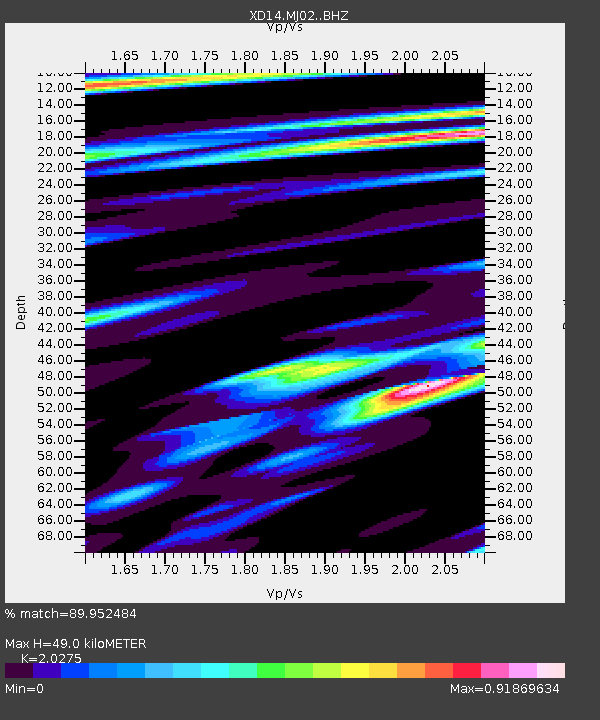
| Estimated Moho Depth: |
49.0 km |
| Estimated Crust Vp/Vs: |
2.03 |
| Assumed Crust Vp: |
6.566 km/s |
| Estimated Crust Vs: |
3.239 km/s |
| Estimated Crust Poisson's Ratio: |
0.34 |
|
| Radial Match: |
89.952484 % |
| Radial Bump: |
400 |
| Transverse Match: |
80.64525 % |
| Transverse Bump: |
400 |
| SOD ConfigId: |
7422571 |
| Insert Time: |
2019-04-17 21:30:37.292 +0000 |
| GWidth: |
2.5 |
| Max Bumps: |
400 |
| Tol: |
0.001 |
|

Signal To Noise
| Channel | StoN | STA | LTA |
| XD:MJ02: :BHZ:20150323T05:03:03.875012Z | 9.324335 | 1.7689782E-6 | 1.8971629E-7 |
| XD:MJ02: :BHN:20150323T05:03:03.875012Z | 2.355987 | 4.6339864E-7 | 1.966898E-7 |
| XD:MJ02: :BHE:20150323T05:03:03.875012Z | 4.3486953 | 6.241159E-7 | 1.4351797E-7 |
| Arrivals |
| Ps | 7.9 SECOND |
| PpPs | 22 SECOND |
| PsPs/PpSs | 30 SECOND |


