You are here: Home > Network List > II - Global Seismograph Network (GSN - IRIS/IDA) Stations List
> Station RAYN Ar Rayn, Saudi Arabia > Earthquake Result Viewer
RAYN Ar Rayn, Saudi Arabia - Earthquake Result Viewer

| Earthquake location: |
Southern Sumatra, Indonesia |
| Earthquake latitude/longitude: |
-4.0/101.7 |
| Earthquake time(UTC): |
2001/01/16 (016) 13:25:01 GMT |
| Earthquake Depth: |
33 km |
| Earthquake Magnitude: |
6.0 MB |
| Earthquake Catalog/Contributor: |
WHDF/NEIC |
|
| Network: |
II Global Seismograph Network (GSN - IRIS/IDA) |
| Station: |
RAYN Ar Rayn, Saudi Arabia |
| Lat/Lon: |
23.52 N/45.50 E |
| Elevation: |
631 m |
|
| Distance: |
61.2 deg |
| Az: |
299.451 deg |
| Baz: |
108.835 deg |
| Ray Param: |
0.060967367 |
| Estimated Moho Depth: |
40.75 km |
| Estimated Crust Vp/Vs: |
1.76 |
| Assumed Crust Vp: |
6.498 km/s |
| Estimated Crust Vs: |
3.692 km/s |
| Estimated Crust Poisson's Ratio: |
0.26 |
|
| Radial Match: |
97.78185 % |
| Radial Bump: |
212 |
| Transverse Match: |
91.25056 % |
| Transverse Bump: |
400 |
| SOD ConfigId: |
3744 |
| Insert Time: |
2010-03-01 23:35:11.040 +0000 |
| GWidth: |
2.5 |
| Max Bumps: |
400 |
| Tol: |
0.001 |
|
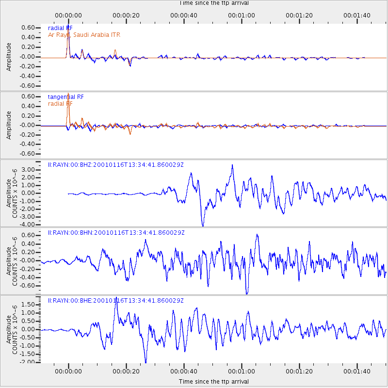
Signal To Noise
| Channel | StoN | STA | LTA |
| II:RAYN:00:BHN:20010116T13:34:41.860029Z | 1.7606285 | 5.1946213E-8 | 2.9504358E-8 |
| II:RAYN:00:BHE:20010116T13:34:41.860029Z | 4.1491656 | 1.6088532E-7 | 3.8775344E-8 |
| II:RAYN:00:BHZ:20010116T13:34:41.860029Z | 5.14103 | 3.0919009E-7 | 6.0141666E-8 |
| Arrivals |
| Ps | 5.0 SECOND |
| PpPs | 17 SECOND |
| PsPs/PpSs | 22 SECOND |


