You are here: Home > Network List > G - GEOSCOPE Stations List
> Station MPG Montagne des Peres, French Guyana > Earthquake Result Viewer
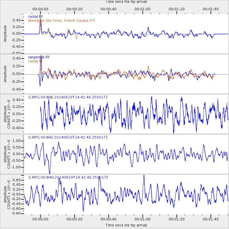
MPG Montagne des Peres, French Guyana - Earthquake Result Viewer
*The percent match for this event was below the threshold and hence no stack was calculated.
| Earthquake location: |
South Sandwich Islands Region |
| Earthquake latitude/longitude: |
-55.4/-28.1 |
| Earthquake time(UTC): |
2014/06/29 (180) 14:32:49 GMT |
| Earthquake Depth: |
10 km |
| Earthquake Magnitude: |
5.7 MB, 6.0 MWC, 6.0 MWB |
| Earthquake Catalog/Contributor: |
NEIC PDE/NEIC COMCAT |
|
| Network: |
G GEOSCOPE |
| Station: |
MPG Montagne des Peres, French Guyana |
| Lat/Lon: |
5.11 N/52.64 W |
| Elevation: |
147 m |
|
| Distance: |
63.6 deg |
| Az: |
332.532 deg |
| Baz: |
164.679 deg |
| Ray Param: |
$rayparam |
*The percent match for this event was below the threshold and hence was not used in the summary stack. |
|
| Radial Match: |
64.02148 % |
| Radial Bump: |
400 |
| Transverse Match: |
63.161446 % |
| Transverse Bump: |
400 |
| SOD ConfigId: |
751272 |
| Insert Time: |
2014-07-13 14:46:12.932 +0000 |
| GWidth: |
2.5 |
| Max Bumps: |
400 |
| Tol: |
0.001 |
|
Signal To Noise
| Channel | StoN | STA | LTA |
| G:MPG:00:BHZ:20140629T14:42:49.250017Z | 2.9410279 | 4.907648E-7 | 1.6686847E-7 |
| G:MPG:00:BHN:20140629T14:42:49.250017Z | 1.113201 | 2.3506888E-7 | 2.111648E-7 |
| G:MPG:00:BHE:20140629T14:42:49.250017Z | 0.7274719 | 1.3547057E-7 | 1.8622103E-7 |
| Arrivals |
| Ps | |
| PpPs | |
| PsPs/PpSs | |


