You are here: Home > Network List > TA - USArray Transportable Network (new EarthScope stations) Stations List
> Station TCOL CIGO, UAF Yankovich Road, Fairbanks, AK, USA > Earthquake Result Viewer
TCOL CIGO, UAF Yankovich Road, Fairbanks, AK, USA - Earthquake Result Viewer
| Earthquake location: |
Samoa Islands Region |
| Earthquake latitude/longitude: |
-14.8/-175.3 |
| Earthquake time(UTC): |
2014/06/29 (180) 15:52:22 GMT |
| Earthquake Depth: |
10 km |
| Earthquake Magnitude: |
6.4 MWW, 6.4 MWB, 6.5 MWC, 6.8 MI |
| Earthquake Catalog/Contributor: |
NEIC PDE/NEIC COMCAT |
|
| Network: |
TA USArray Transportable Network (new EarthScope stations) |
| Station: |
TCOL CIGO, UAF Yankovich Road, Fairbanks, AK, USA |
| Lat/Lon: |
64.87 N/147.86 W |
| Elevation: |
178 m |
|
| Distance: |
82.1 deg |
| Az: |
11.442 deg |
| Baz: |
206.711 deg |
| Ray Param: |
0.047130845 |
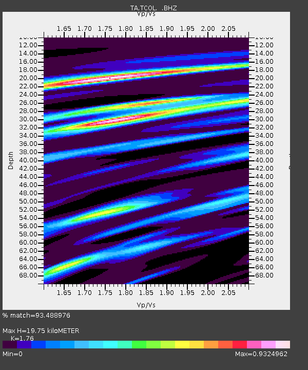
| Estimated Moho Depth: |
19.75 km |
| Estimated Crust Vp/Vs: |
1.76 |
| Assumed Crust Vp: |
6.566 km/s |
| Estimated Crust Vs: |
3.731 km/s |
| Estimated Crust Poisson's Ratio: |
0.26 |
|
| Radial Match: |
93.488976 % |
| Radial Bump: |
400 |
| Transverse Match: |
88.48545 % |
| Transverse Bump: |
337 |
| SOD ConfigId: |
751272 |
| Insert Time: |
2014-07-13 16:21:36.356 +0000 |
| GWidth: |
2.5 |
| Max Bumps: |
400 |
| Tol: |
0.001 |
|

Signal To Noise
| Channel | StoN | STA | LTA |
| TA:TCOL: :BHZ:20140629T16:04:11.825022Z | 1.5950421 | 4.927078E-7 | 3.0889953E-7 |
| TA:TCOL: :BHN:20140629T16:04:11.825022Z | 1.0686852 | 2.0524848E-7 | 1.9205702E-7 |
| TA:TCOL: :BHE:20140629T16:04:11.825022Z | 1.1948063 | 2.9229804E-7 | 2.4464052E-7 |
| Arrivals |
| Ps | 2.4 SECOND |
| PpPs | 8.1 SECOND |
| PsPs/PpSs | 10 SECOND |


