You are here: Home > Network List > UU - University of Utah Regional Network Stations List
> Station BSUT Blindstream Canyon, Hanna, UT, USA > Earthquake Result Viewer
BSUT Blindstream Canyon, Hanna, UT, USA - Earthquake Result Viewer
| Earthquake location: |
Samoa Islands Region |
| Earthquake latitude/longitude: |
-14.8/-175.3 |
| Earthquake time(UTC): |
2014/06/29 (180) 15:52:22 GMT |
| Earthquake Depth: |
10 km |
| Earthquake Magnitude: |
6.4 MWW, 6.4 MWB, 6.5 MWC, 6.8 MI |
| Earthquake Catalog/Contributor: |
NEIC PDE/NEIC COMCAT |
|
| Network: |
UU University of Utah Regional Network |
| Station: |
BSUT Blindstream Canyon, Hanna, UT, USA |
| Lat/Lon: |
40.54 N/110.76 W |
| Elevation: |
3211 m |
|
| Distance: |
81.2 deg |
| Az: |
44.119 deg |
| Baz: |
242.083 deg |
| Ray Param: |
0.04777197 |
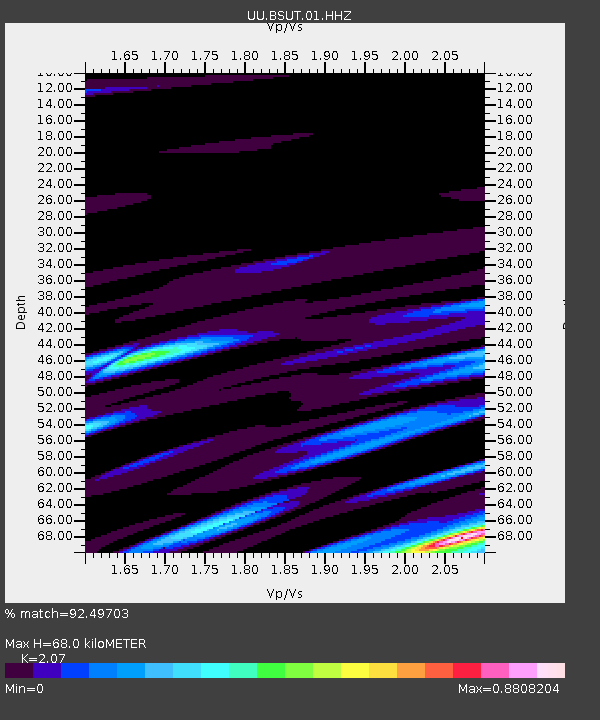
| Estimated Moho Depth: |
68.0 km |
| Estimated Crust Vp/Vs: |
2.07 |
| Assumed Crust Vp: |
6.155 km/s |
| Estimated Crust Vs: |
2.973 km/s |
| Estimated Crust Poisson's Ratio: |
0.35 |
|
| Radial Match: |
92.49703 % |
| Radial Bump: |
259 |
| Transverse Match: |
77.19847 % |
| Transverse Bump: |
400 |
| SOD ConfigId: |
751272 |
| Insert Time: |
2014-07-13 16:23:11.193 +0000 |
| GWidth: |
2.5 |
| Max Bumps: |
400 |
| Tol: |
0.001 |
|

Signal To Noise
| Channel | StoN | STA | LTA |
| UU:BSUT:01:HHZ:20140629T16:04:07.028025Z | 1.0336158 | 4.490566E-9 | 4.344521E-9 |
| UU:BSUT:01:HHN:20140629T16:04:07.028025Z | 1.9115237 | 5.900646E-9 | 3.086881E-9 |
| UU:BSUT:01:HHE:20140629T16:04:07.028025Z | 1.125126 | 5.382731E-9 | 4.784114E-9 |
| Arrivals |
| Ps | 12 SECOND |
| PpPs | 33 SECOND |
| PsPs/PpSs | 45 SECOND |


