You are here: Home > Network List > N4 - Central and EAstern US Network Stations List
> Station N38B Corydon, IA, USA > Earthquake Result Viewer
N38B Corydon, IA, USA - Earthquake Result Viewer
| Earthquake location: |
Tonga Islands |
| Earthquake latitude/longitude: |
-15.0/-175.6 |
| Earthquake time(UTC): |
2014/06/29 (180) 17:15:08 GMT |
| Earthquake Depth: |
10 km |
| Earthquake Magnitude: |
6.7 MWW, 6.7 MWC, 6.8 MI |
| Earthquake Catalog/Contributor: |
NEIC PDE/NEIC COMCAT |
|
| Network: |
N4 Central and EAstern US Network |
| Station: |
N38B Corydon, IA, USA |
| Lat/Lon: |
40.79 N/93.24 W |
| Elevation: |
322 m |
|
| Distance: |
94.0 deg |
| Az: |
48.964 deg |
| Baz: |
253.715 deg |
| Ray Param: |
0.04114242 |
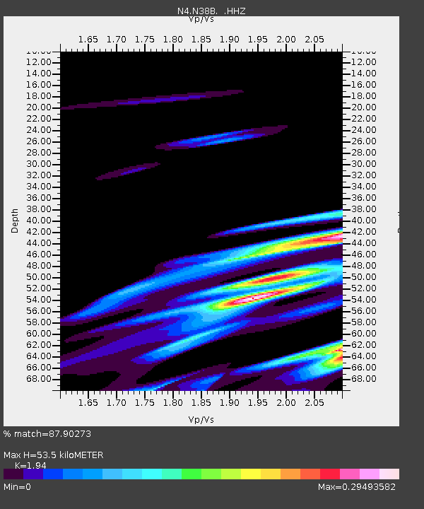
| Estimated Moho Depth: |
53.5 km |
| Estimated Crust Vp/Vs: |
1.94 |
| Assumed Crust Vp: |
6.498 km/s |
| Estimated Crust Vs: |
3.349 km/s |
| Estimated Crust Poisson's Ratio: |
0.32 |
|
| Radial Match: |
87.90273 % |
| Radial Bump: |
323 |
| Transverse Match: |
78.52269 % |
| Transverse Bump: |
400 |
| SOD ConfigId: |
751272 |
| Insert Time: |
2014-07-13 17:35:29.985 +0000 |
| GWidth: |
2.5 |
| Max Bumps: |
400 |
| Tol: |
0.001 |
|

Signal To Noise
| Channel | StoN | STA | LTA |
| N4:N38B: :HHZ:20140629T17:27:54.97999Z | 2.0347896 | 1.0268656E-6 | 5.0465445E-7 |
| N4:N38B: :HHN:20140629T17:27:54.97999Z | 1.3199127 | 2.6667007E-7 | 2.0203615E-7 |
| N4:N38B: :HHE:20140629T17:27:54.97999Z | 1.0716801 | 4.41016E-7 | 4.1151836E-7 |
| Arrivals |
| Ps | 7.9 SECOND |
| PpPs | 24 SECOND |
| PsPs/PpSs | 32 SECOND |


