You are here: Home > Network List > TA - USArray Transportable Network (new EarthScope stations) Stations List
> Station N23A Red Feather Lakes, CO, USA > Earthquake Result Viewer
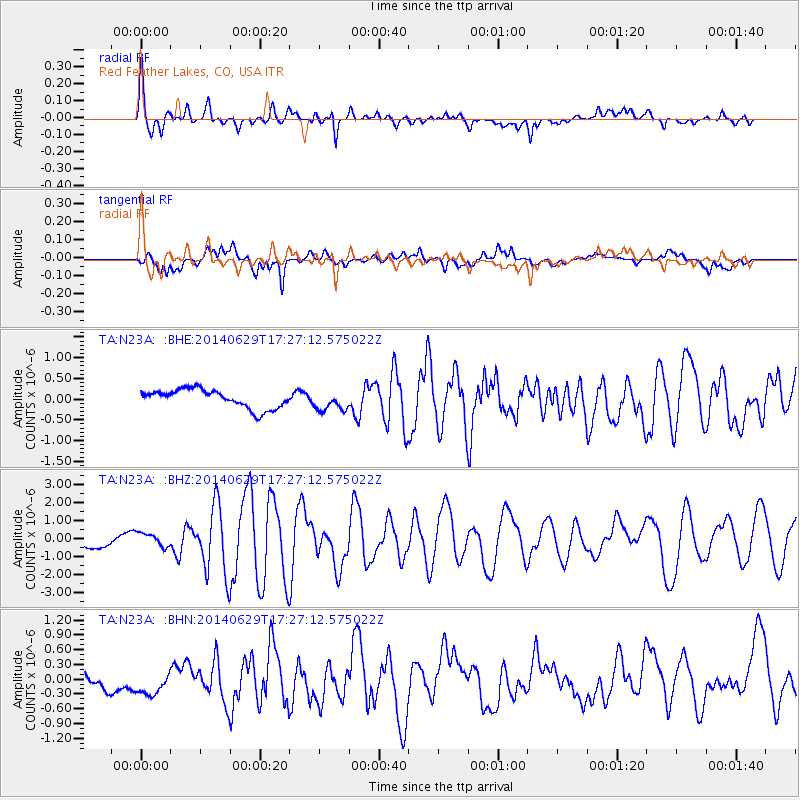
N23A Red Feather Lakes, CO, USA - Earthquake Result Viewer

| Earthquake location: |
Tonga Islands |
| Earthquake latitude/longitude: |
-15.0/-175.6 |
| Earthquake time(UTC): |
2014/06/29 (180) 17:15:08 GMT |
| Earthquake Depth: |
10 km |
| Earthquake Magnitude: |
6.7 MWW, 6.7 MWC, 6.8 MI |
| Earthquake Catalog/Contributor: |
NEIC PDE/NEIC COMCAT |
|
| Network: |
TA USArray Transportable Network (new EarthScope stations) |
| Station: |
N23A Red Feather Lakes, CO, USA |
| Lat/Lon: |
40.89 N/105.94 W |
| Elevation: |
2458 m |
|
| Distance: |
85.0 deg |
| Az: |
45.507 deg |
| Baz: |
245.386 deg |
| Ray Param: |
0.045065414 |
| Estimated Moho Depth: |
56.25 km |
| Estimated Crust Vp/Vs: |
1.86 |
| Assumed Crust Vp: |
6.306 km/s |
| Estimated Crust Vs: |
3.39 km/s |
| Estimated Crust Poisson's Ratio: |
0.30 |
|
| Radial Match: |
87.29466 % |
| Radial Bump: |
400 |
| Transverse Match: |
77.18356 % |
| Transverse Bump: |
400 |
| SOD ConfigId: |
751272 |
| Insert Time: |
2014-07-13 17:39:54.071 +0000 |
| GWidth: |
2.5 |
| Max Bumps: |
400 |
| Tol: |
0.001 |
|
Signal To Noise
| Channel | StoN | STA | LTA |
| TA:N23A: :BHZ:20140629T17:27:12.575022Z | 0.9932002 | 3.8401552E-7 | 3.8664464E-7 |
| TA:N23A: :BHN:20140629T17:27:12.575022Z | 1.3382881 | 3.1940382E-7 | 2.38666E-7 |
| TA:N23A: :BHE:20140629T17:27:12.575022Z | 1.056837 | 2.379633E-7 | 2.2516558E-7 |
| Arrivals |
| Ps | 7.8 SECOND |
| PpPs | 25 SECOND |
| PsPs/PpSs | 33 SECOND |


