You are here: Home > Network List > TA - USArray Transportable Network (new EarthScope stations) Stations List
> Station MSTX Muleshoe, TX, USA > Earthquake Result Viewer
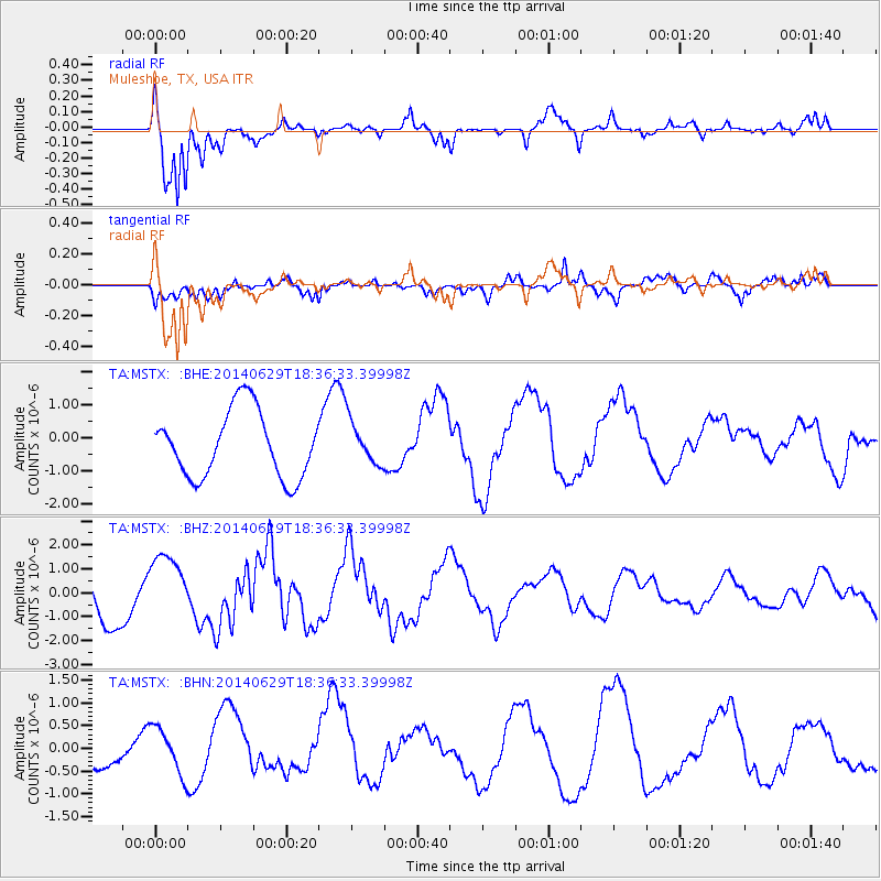
MSTX Muleshoe, TX, USA - Earthquake Result Viewer
*The percent match for this event was below the threshold and hence no stack was calculated.
| Earthquake location: |
Tonga Islands |
| Earthquake latitude/longitude: |
-15.4/-175.4 |
| Earthquake time(UTC): |
2014/06/29 (180) 18:24:30 GMT |
| Earthquake Depth: |
10 km |
| Earthquake Magnitude: |
5.6 MB |
| Earthquake Catalog/Contributor: |
NEIC PDE/NEIC COMCAT |
|
| Network: |
TA USArray Transportable Network (new EarthScope stations) |
| Station: |
MSTX Muleshoe, TX, USA |
| Lat/Lon: |
33.97 N/102.77 W |
| Elevation: |
1167 m |
|
| Distance: |
84.7 deg |
| Az: |
52.823 deg |
| Baz: |
247.659 deg |
| Ray Param: |
$rayparam |
*The percent match for this event was below the threshold and hence was not used in the summary stack. |
|
| Radial Match: |
87.66709 % |
| Radial Bump: |
335 |
| Transverse Match: |
64.333725 % |
| Transverse Bump: |
400 |
| SOD ConfigId: |
751272 |
| Insert Time: |
2014-07-13 18:44:27.932 +0000 |
| GWidth: |
2.5 |
| Max Bumps: |
400 |
| Tol: |
0.001 |
|
Signal To Noise
| Channel | StoN | STA | LTA |
| TA:MSTX: :BHZ:20140629T18:36:33.39998Z | 1.4998719 | 1.3462682E-6 | 8.9758885E-7 |
| TA:MSTX: :BHN:20140629T18:36:33.39998Z | 1.3187983 | 5.156466E-7 | 3.9099734E-7 |
| TA:MSTX: :BHE:20140629T18:36:33.39998Z | 0.6455363 | 6.47353E-7 | 1.0028142E-6 |
| Arrivals |
| Ps | |
| PpPs | |
| PsPs/PpSs | |


