You are here: Home > Network List > US - United States National Seismic Network Stations List
> Station HAWA Hanford, Washington, USA > Earthquake Result Viewer
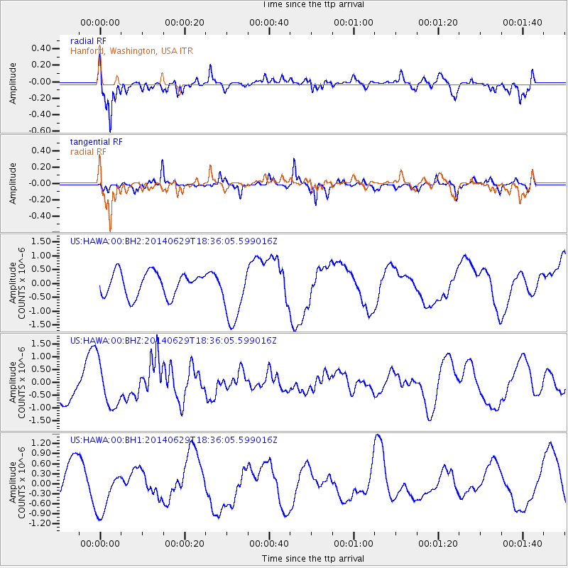
HAWA Hanford, Washington, USA - Earthquake Result Viewer
*The percent match for this event was below the threshold and hence no stack was calculated.
| Earthquake location: |
Tonga Islands |
| Earthquake latitude/longitude: |
-15.4/-175.4 |
| Earthquake time(UTC): |
2014/06/29 (180) 18:24:30 GMT |
| Earthquake Depth: |
10 km |
| Earthquake Magnitude: |
5.6 MB |
| Earthquake Catalog/Contributor: |
NEIC PDE/NEIC COMCAT |
|
| Network: |
US United States National Seismic Network |
| Station: |
HAWA Hanford, Washington, USA |
| Lat/Lon: |
46.39 N/119.53 W |
| Elevation: |
364 m |
|
| Distance: |
79.4 deg |
| Az: |
35.677 deg |
| Baz: |
234.383 deg |
| Ray Param: |
$rayparam |
*The percent match for this event was below the threshold and hence was not used in the summary stack. |
|
| Radial Match: |
70.57287 % |
| Radial Bump: |
400 |
| Transverse Match: |
59.73519 % |
| Transverse Bump: |
300 |
| SOD ConfigId: |
751272 |
| Insert Time: |
2014-07-13 18:45:39.557 +0000 |
| GWidth: |
2.5 |
| Max Bumps: |
400 |
| Tol: |
0.001 |
|
Signal To Noise
| Channel | StoN | STA | LTA |
| US:HAWA:00:BHZ:20140629T18:36:05.599016Z | 1.5144148 | 8.449801E-7 | 5.579582E-7 |
| US:HAWA:00:BH1:20140629T18:36:05.599016Z | 1.8827231 | 6.6967925E-7 | 3.5569715E-7 |
| US:HAWA:00:BH2:20140629T18:36:05.599016Z | 2.4800646 | 1.0692753E-6 | 4.3114812E-7 |
| Arrivals |
| Ps | |
| PpPs | |
| PsPs/PpSs | |


