You are here: Home > Network List > US - United States National Seismic Network Stations List
> Station MIAR Mount Ida, Arkansas, USA > Earthquake Result Viewer
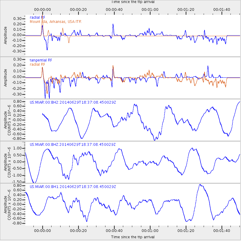
MIAR Mount Ida, Arkansas, USA - Earthquake Result Viewer
*The percent match for this event was below the threshold and hence no stack was calculated.
| Earthquake location: |
Tonga Islands |
| Earthquake latitude/longitude: |
-15.4/-175.4 |
| Earthquake time(UTC): |
2014/06/29 (180) 18:24:30 GMT |
| Earthquake Depth: |
10 km |
| Earthquake Magnitude: |
5.6 MB |
| Earthquake Catalog/Contributor: |
NEIC PDE/NEIC COMCAT |
|
| Network: |
US United States National Seismic Network |
| Station: |
MIAR Mount Ida, Arkansas, USA |
| Lat/Lon: |
34.55 N/93.58 W |
| Elevation: |
207 m |
|
| Distance: |
92.1 deg |
| Az: |
54.854 deg |
| Baz: |
252.877 deg |
| Ray Param: |
$rayparam |
*The percent match for this event was below the threshold and hence was not used in the summary stack. |
|
| Radial Match: |
77.619995 % |
| Radial Bump: |
400 |
| Transverse Match: |
73.82841 % |
| Transverse Bump: |
400 |
| SOD ConfigId: |
751272 |
| Insert Time: |
2014-07-13 18:45:54.793 +0000 |
| GWidth: |
2.5 |
| Max Bumps: |
400 |
| Tol: |
0.001 |
|
Signal To Noise
| Channel | StoN | STA | LTA |
| US:MIAR:00:BHZ:20140629T18:37:08.450029Z | 1.066831 | 7.3546516E-7 | 6.893923E-7 |
| US:MIAR:00:BH1:20140629T18:37:08.450029Z | 0.9143794 | 2.7746296E-7 | 3.03444E-7 |
| US:MIAR:00:BH2:20140629T18:37:08.450029Z | 1.0903654 | 4.1085082E-7 | 3.7680104E-7 |
| Arrivals |
| Ps | |
| PpPs | |
| PsPs/PpSs | |


