You are here: Home > Network List > US - United States National Seismic Network Stations List
> Station WMOK Wichita Mountains, Oklahoma, USA > Earthquake Result Viewer
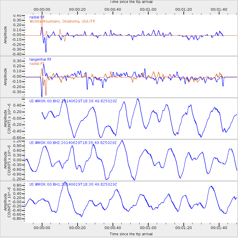
WMOK Wichita Mountains, Oklahoma, USA - Earthquake Result Viewer
*The percent match for this event was below the threshold and hence no stack was calculated.
| Earthquake location: |
Tonga Islands |
| Earthquake latitude/longitude: |
-15.4/-175.4 |
| Earthquake time(UTC): |
2014/06/29 (180) 18:24:30 GMT |
| Earthquake Depth: |
10 km |
| Earthquake Magnitude: |
5.6 MB |
| Earthquake Catalog/Contributor: |
NEIC PDE/NEIC COMCAT |
|
| Network: |
US United States National Seismic Network |
| Station: |
WMOK Wichita Mountains, Oklahoma, USA |
| Lat/Lon: |
34.74 N/98.78 W |
| Elevation: |
486 m |
|
| Distance: |
88.1 deg |
| Az: |
53.304 deg |
| Baz: |
249.932 deg |
| Ray Param: |
$rayparam |
*The percent match for this event was below the threshold and hence was not used in the summary stack. |
|
| Radial Match: |
53.55945 % |
| Radial Bump: |
371 |
| Transverse Match: |
68.581474 % |
| Transverse Bump: |
400 |
| SOD ConfigId: |
751272 |
| Insert Time: |
2014-07-13 18:46:09.746 +0000 |
| GWidth: |
2.5 |
| Max Bumps: |
400 |
| Tol: |
0.001 |
|
Signal To Noise
| Channel | StoN | STA | LTA |
| US:WMOK:00:BHZ:20140629T18:36:49.825029Z | 0.97790223 | 6.434111E-7 | 6.579503E-7 |
| US:WMOK:00:BH1:20140629T18:36:49.825029Z | 0.35782373 | 1.2269072E-7 | 3.4288033E-7 |
| US:WMOK:00:BH2:20140629T18:36:49.825029Z | 1.5204519 | 4.2983157E-7 | 2.826999E-7 |
| Arrivals |
| Ps | |
| PpPs | |
| PsPs/PpSs | |


