You are here: Home > Network List > UW - Pacific Northwest Regional Seismic Network Stations List
> Station MRBL Marblemount, WA, USA > Earthquake Result Viewer
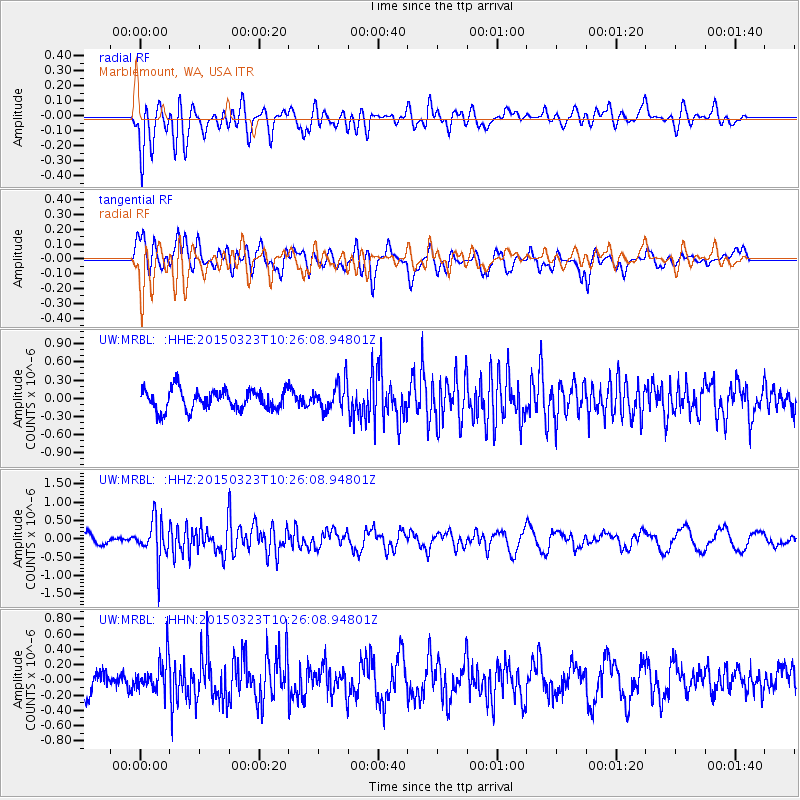
MRBL Marblemount, WA, USA - Earthquake Result Viewer
*The percent match for this event was below the threshold and hence no stack was calculated.
| Earthquake location: |
Taiwan |
| Earthquake latitude/longitude: |
23.7/121.7 |
| Earthquake time(UTC): |
2015/03/23 (082) 10:13:50 GMT |
| Earthquake Depth: |
31 km |
| Earthquake Magnitude: |
5.9 MB |
| Earthquake Catalog/Contributor: |
NEIC PDE/NEIC ALERT |
|
| Network: |
UW Pacific Northwest Regional Seismic Network |
| Station: |
MRBL Marblemount, WA, USA |
| Lat/Lon: |
48.52 N/121.48 W |
| Elevation: |
75 m |
|
| Distance: |
88.7 deg |
| Az: |
36.401 deg |
| Baz: |
305.099 deg |
| Ray Param: |
$rayparam |
*The percent match for this event was below the threshold and hence was not used in the summary stack. |
|
| Radial Match: |
65.09278 % |
| Radial Bump: |
400 |
| Transverse Match: |
61.821205 % |
| Transverse Bump: |
367 |
| SOD ConfigId: |
7422571 |
| Insert Time: |
2019-04-17 21:37:38.110 +0000 |
| GWidth: |
2.5 |
| Max Bumps: |
400 |
| Tol: |
0.001 |
|
Signal To Noise
| Channel | StoN | STA | LTA |
| UW:MRBL: :HHZ:20150323T10:26:08.94801Z | 4.514881 | 5.627619E-7 | 1.2464601E-7 |
| UW:MRBL: :HHN:20150323T10:26:08.94801Z | 1.411139 | 2.214478E-7 | 1.5692841E-7 |
| UW:MRBL: :HHE:20150323T10:26:08.94801Z | 1.4378979 | 2.4243988E-7 | 1.6860717E-7 |
| Arrivals |
| Ps | |
| PpPs | |
| PsPs/PpSs | |


