You are here: Home > Network List > II - Global Seismograph Network (GSN - IRIS/IDA) Stations List
> Station RAYN Ar Rayn, Saudi Arabia > Earthquake Result Viewer
RAYN Ar Rayn, Saudi Arabia - Earthquake Result Viewer
| Earthquake location: |
Kuril Islands |
| Earthquake latitude/longitude: |
44.3/150.0 |
| Earthquake time(UTC): |
2002/10/19 (292) 12:09:05 GMT |
| Earthquake Depth: |
33 km |
| Earthquake Magnitude: |
5.4 MB, 6.2 MS, 6.4 MW, 6.1 MW |
| Earthquake Catalog/Contributor: |
WHDF/NEIC |
|
| Network: |
II Global Seismograph Network (GSN - IRIS/IDA) |
| Station: |
RAYN Ar Rayn, Saudi Arabia |
| Lat/Lon: |
23.52 N/45.50 E |
| Elevation: |
631 m |
|
| Distance: |
83.6 deg |
| Az: |
296.567 deg |
| Baz: |
44.404 deg |
| Ray Param: |
0.046036452 |
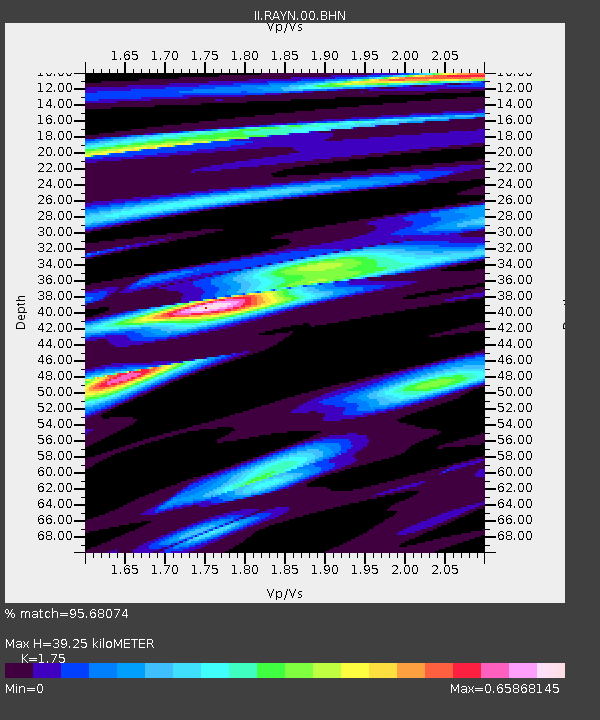
| Estimated Moho Depth: |
39.25 km |
| Estimated Crust Vp/Vs: |
1.75 |
| Assumed Crust Vp: |
6.498 km/s |
| Estimated Crust Vs: |
3.713 km/s |
| Estimated Crust Poisson's Ratio: |
0.26 |
|
| Radial Match: |
95.68074 % |
| Radial Bump: |
265 |
| Transverse Match: |
85.84212 % |
| Transverse Bump: |
400 |
| SOD ConfigId: |
4714 |
| Insert Time: |
2010-03-01 23:36:52.526 +0000 |
| GWidth: |
2.5 |
| Max Bumps: |
400 |
| Tol: |
0.001 |
|

Signal To Noise
| Channel | StoN | STA | LTA |
| II:RAYN:00:BHN:20021019T12:20:59.108027Z | 2.8241045 | 1.3718348E-7 | 4.8575917E-8 |
| II:RAYN:00:BHE:20021019T12:20:59.108027Z | 2.6083066 | 1.2319191E-7 | 4.7230607E-8 |
| II:RAYN:00:BHZ:20021019T12:20:59.108027Z | 8.241546 | 4.6009E-7 | 5.5825698E-8 |
| Arrivals |
| Ps | 4.7 SECOND |
| PpPs | 16 SECOND |
| PsPs/PpSs | 21 SECOND |


