You are here: Home > Network List > TA - USArray Transportable Network (new EarthScope stations) Stations List
> Station MSTX Muleshoe, TX, USA > Earthquake Result Viewer
MSTX Muleshoe, TX, USA - Earthquake Result Viewer
*The percent match for this event was below the threshold and hence no stack was calculated.
| Earthquake location: |
North Of Ascension Island |
| Earthquake latitude/longitude: |
0.0/-17.3 |
| Earthquake time(UTC): |
2014/06/30 (181) 01:46:23 GMT |
| Earthquake Depth: |
8.0 km |
| Earthquake Magnitude: |
5.8 MB |
| Earthquake Catalog/Contributor: |
NEIC PDE/NEIC COMCAT |
|
| Network: |
TA USArray Transportable Network (new EarthScope stations) |
| Station: |
MSTX Muleshoe, TX, USA |
| Lat/Lon: |
33.97 N/102.77 W |
| Elevation: |
1167 m |
|
| Distance: |
86.2 deg |
| Az: |
303.874 deg |
| Baz: |
92.515 deg |
| Ray Param: |
$rayparam |
*The percent match for this event was below the threshold and hence was not used in the summary stack. |
|
| Radial Match: |
48.00496 % |
| Radial Bump: |
400 |
| Transverse Match: |
51.33149 % |
| Transverse Bump: |
400 |
| SOD ConfigId: |
751272 |
| Insert Time: |
2014-07-14 02:34:17.076 +0000 |
| GWidth: |
2.5 |
| Max Bumps: |
400 |
| Tol: |
0.001 |
|
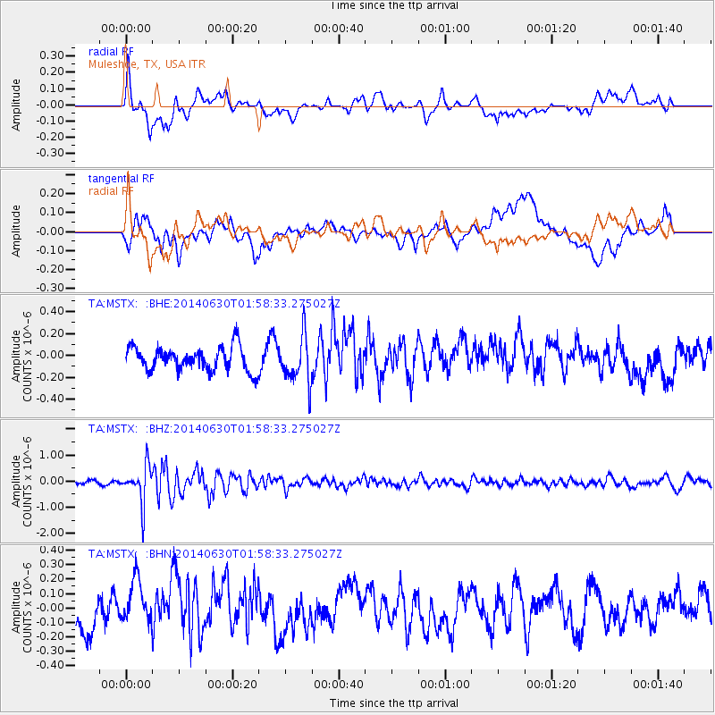
Signal To Noise
| Channel | StoN | STA | LTA |
| TA:MSTX: :BHZ:20140630T01:58:33.275027Z | 6.861707 | 7.15852E-7 | 1.0432565E-7 |
| TA:MSTX: :BHN:20140630T01:58:33.275027Z | 1.3756212 | 1.6198555E-7 | 1.17754475E-7 |
| TA:MSTX: :BHE:20140630T01:58:33.275027Z | 1.9882069 | 2.1555655E-7 | 1.0841757E-7 |
| Arrivals |
| Ps | |
| PpPs | |
| PsPs/PpSs | |


