You are here: Home > Network List > II - Global Seismograph Network (GSN - IRIS/IDA) Stations List
> Station RAYN Ar Rayn, Saudi Arabia > Earthquake Result Viewer
RAYN Ar Rayn, Saudi Arabia - Earthquake Result Viewer
| Earthquake location: |
East Of Kuril Islands |
| Earthquake latitude/longitude: |
48.8/156.3 |
| Earthquake time(UTC): |
2004/12/18 (353) 06:46:19 GMT |
| Earthquake Depth: |
11 km |
| Earthquake Magnitude: |
5.5 MB, 6.1 MS, 6.2 MW, 6.1 MW |
| Earthquake Catalog/Contributor: |
WHDF/NEIC |
|
| Network: |
II Global Seismograph Network (GSN - IRIS/IDA) |
| Station: |
RAYN Ar Rayn, Saudi Arabia |
| Lat/Lon: |
23.52 N/45.50 E |
| Elevation: |
631 m |
|
| Distance: |
85.3 deg |
| Az: |
300.576 deg |
| Baz: |
38.297 deg |
| Ray Param: |
0.044884413 |
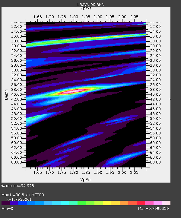
| Estimated Moho Depth: |
38.5 km |
| Estimated Crust Vp/Vs: |
1.80 |
| Assumed Crust Vp: |
6.498 km/s |
| Estimated Crust Vs: |
3.62 km/s |
| Estimated Crust Poisson's Ratio: |
0.27 |
|
| Radial Match: |
94.975 % |
| Radial Bump: |
309 |
| Transverse Match: |
83.52558 % |
| Transverse Bump: |
400 |
| SOD ConfigId: |
2459 |
| Insert Time: |
2010-03-01 23:37:45.331 +0000 |
| GWidth: |
2.5 |
| Max Bumps: |
400 |
| Tol: |
0.001 |
|

Signal To Noise
| Channel | StoN | STA | LTA |
| II:RAYN:00:BHN:20041218T06:58:25.041997Z | 5.533363 | 2.4017592E-7 | 4.3405056E-8 |
| II:RAYN:00:BHE:20041218T06:58:25.041997Z | 1.6664723 | 1.9213272E-7 | 1.1529307E-7 |
| II:RAYN:00:BHZ:20041218T06:58:25.041997Z | 18.155443 | 8.363931E-7 | 4.6068447E-8 |
| Arrivals |
| Ps | 4.8 SECOND |
| PpPs | 16 SECOND |
| PsPs/PpSs | 21 SECOND |


