You are here: Home > Network List > TA - USArray Transportable Network (new EarthScope stations) Stations List
> Station P54A Burton, WV, USA > Earthquake Result Viewer
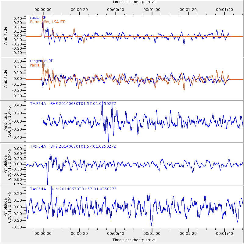
P54A Burton, WV, USA - Earthquake Result Viewer
*The percent match for this event was below the threshold and hence no stack was calculated.
| Earthquake location: |
North Of Ascension Island |
| Earthquake latitude/longitude: |
0.0/-17.3 |
| Earthquake time(UTC): |
2014/06/30 (181) 01:46:23 GMT |
| Earthquake Depth: |
8.0 km |
| Earthquake Magnitude: |
5.8 MB |
| Earthquake Catalog/Contributor: |
NEIC PDE/NEIC COMCAT |
|
| Network: |
TA USArray Transportable Network (new EarthScope stations) |
| Station: |
P54A Burton, WV, USA |
| Lat/Lon: |
39.61 N/80.48 W |
| Elevation: |
473 m |
|
| Distance: |
69.5 deg |
| Az: |
312.648 deg |
| Baz: |
107.8 deg |
| Ray Param: |
$rayparam |
*The percent match for this event was below the threshold and hence was not used in the summary stack. |
|
| Radial Match: |
71.91278 % |
| Radial Bump: |
400 |
| Transverse Match: |
59.629745 % |
| Transverse Bump: |
400 |
| SOD ConfigId: |
751272 |
| Insert Time: |
2014-07-14 02:36:13.205 +0000 |
| GWidth: |
2.5 |
| Max Bumps: |
400 |
| Tol: |
0.001 |
|
Signal To Noise
| Channel | StoN | STA | LTA |
| TA:P54A: :BHZ:20140630T01:57:01.025027Z | 3.8495848 | 3.7573167E-7 | 9.760317E-8 |
| TA:P54A: :BHN:20140630T01:57:01.025027Z | 1.710586 | 1.0358531E-7 | 6.055546E-8 |
| TA:P54A: :BHE:20140630T01:57:01.025027Z | 2.5829718 | 1.7261063E-7 | 6.682637E-8 |
| Arrivals |
| Ps | |
| PpPs | |
| PsPs/PpSs | |


