You are here: Home > Network List > TA - USArray Transportable Network (new EarthScope stations) Stations List
> Station P57A Homestead Farm, Martinsburg, WV, USA > Earthquake Result Viewer
P57A Homestead Farm, Martinsburg, WV, USA - Earthquake Result Viewer
*The percent match for this event was below the threshold and hence no stack was calculated.
| Earthquake location: |
North Of Ascension Island |
| Earthquake latitude/longitude: |
0.0/-17.3 |
| Earthquake time(UTC): |
2014/06/30 (181) 01:46:23 GMT |
| Earthquake Depth: |
8.0 km |
| Earthquake Magnitude: |
5.8 MB |
| Earthquake Catalog/Contributor: |
NEIC PDE/NEIC COMCAT |
|
| Network: |
TA USArray Transportable Network (new EarthScope stations) |
| Station: |
P57A Homestead Farm, Martinsburg, WV, USA |
| Lat/Lon: |
39.48 N/78.01 W |
| Elevation: |
191 m |
|
| Distance: |
67.7 deg |
| Az: |
313.177 deg |
| Baz: |
109.558 deg |
| Ray Param: |
$rayparam |
*The percent match for this event was below the threshold and hence was not used in the summary stack. |
|
| Radial Match: |
47.628483 % |
| Radial Bump: |
400 |
| Transverse Match: |
9.139963 % |
| Transverse Bump: |
400 |
| SOD ConfigId: |
751272 |
| Insert Time: |
2014-07-14 02:36:27.608 +0000 |
| GWidth: |
2.5 |
| Max Bumps: |
400 |
| Tol: |
0.001 |
|
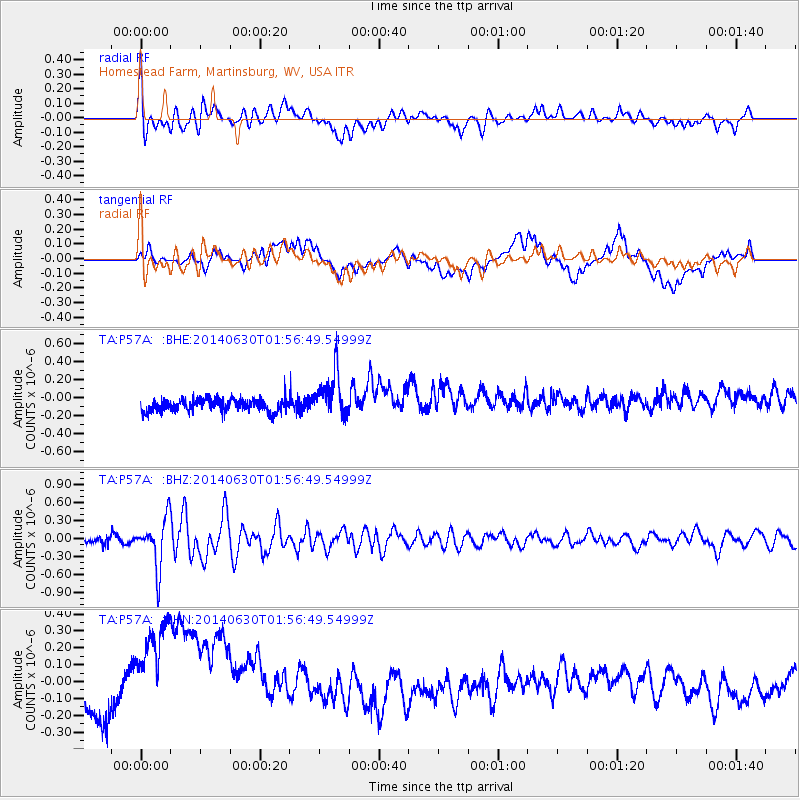
Signal To Noise
| Channel | StoN | STA | LTA |
| TA:P57A: :BHZ:20140630T01:56:49.54999Z | 5.446927 | 4.0666606E-7 | 7.465972E-8 |
| TA:P57A: :BHN:20140630T01:56:49.54999Z | 2.2367647 | 5.70982E-7 | 2.552714E-7 |
| TA:P57A: :BHE:20140630T01:56:49.54999Z | 3.5273337 | 2.559804E-7 | 7.257051E-8 |
| Arrivals |
| Ps | |
| PpPs | |
| PsPs/PpSs | |


