You are here: Home > Network List > TA - USArray Transportable Network (new EarthScope stations) Stations List
> Station Q56A Snyder Ridge, Maysville, WV, USA > Earthquake Result Viewer
Q56A Snyder Ridge, Maysville, WV, USA - Earthquake Result Viewer
| Earthquake location: |
North Of Ascension Island |
| Earthquake latitude/longitude: |
0.0/-17.3 |
| Earthquake time(UTC): |
2014/06/30 (181) 01:46:23 GMT |
| Earthquake Depth: |
8.0 km |
| Earthquake Magnitude: |
5.8 MB |
| Earthquake Catalog/Contributor: |
NEIC PDE/NEIC COMCAT |
|
| Network: |
TA USArray Transportable Network (new EarthScope stations) |
| Station: |
Q56A Snyder Ridge, Maysville, WV, USA |
| Lat/Lon: |
39.04 N/79.19 W |
| Elevation: |
430 m |
|
| Distance: |
68.4 deg |
| Az: |
312.405 deg |
| Baz: |
108.529 deg |
| Ray Param: |
0.056320794 |
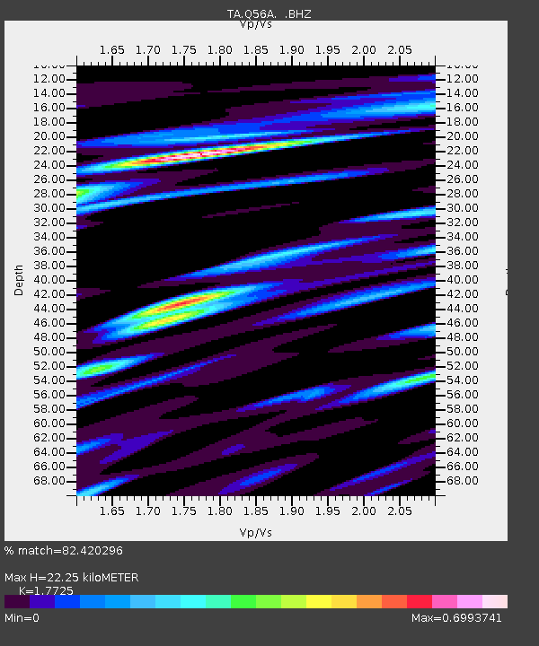
| Estimated Moho Depth: |
22.25 km |
| Estimated Crust Vp/Vs: |
1.77 |
| Assumed Crust Vp: |
6.159 km/s |
| Estimated Crust Vs: |
3.475 km/s |
| Estimated Crust Poisson's Ratio: |
0.27 |
|
| Radial Match: |
82.420296 % |
| Radial Bump: |
400 |
| Transverse Match: |
65.024635 % |
| Transverse Bump: |
400 |
| SOD ConfigId: |
751272 |
| Insert Time: |
2014-07-14 02:37:05.711 +0000 |
| GWidth: |
2.5 |
| Max Bumps: |
400 |
| Tol: |
0.001 |
|
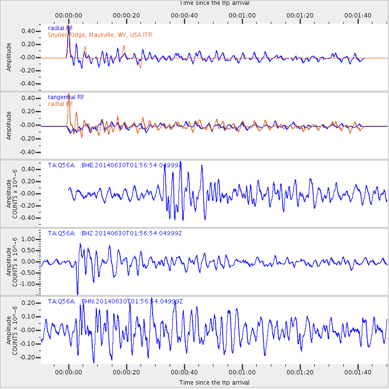
Signal To Noise
| Channel | StoN | STA | LTA |
| TA:Q56A: :BHZ:20140630T01:56:54.04999Z | 6.5699368 | 4.6556914E-7 | 7.0863564E-8 |
| TA:Q56A: :BHN:20140630T01:56:54.04999Z | 1.5596217 | 8.2271725E-8 | 5.2751076E-8 |
| TA:Q56A: :BHE:20140630T01:56:54.04999Z | 2.8429275 | 1.7620728E-7 | 6.198093E-8 |
| Arrivals |
| Ps | 2.9 SECOND |
| PpPs | 9.7 SECOND |
| PsPs/PpSs | 13 SECOND |


