You are here: Home > Network List > TA - USArray Transportable Network (new EarthScope stations) Stations List
> Station U59A Littleton, NC, USA > Earthquake Result Viewer
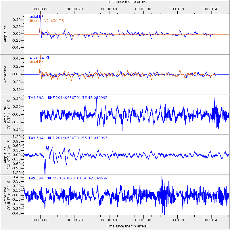
U59A Littleton, NC, USA - Earthquake Result Viewer
*The percent match for this event was below the threshold and hence no stack was calculated.
| Earthquake location: |
North Of Ascension Island |
| Earthquake latitude/longitude: |
0.0/-17.3 |
| Earthquake time(UTC): |
2014/06/30 (181) 01:46:23 GMT |
| Earthquake Depth: |
8.0 km |
| Earthquake Magnitude: |
5.8 MB |
| Earthquake Catalog/Contributor: |
NEIC PDE/NEIC COMCAT |
|
| Network: |
TA USArray Transportable Network (new EarthScope stations) |
| Station: |
U59A Littleton, NC, USA |
| Lat/Lon: |
36.35 N/77.79 W |
| Elevation: |
99 m |
|
| Distance: |
66.5 deg |
| Az: |
310.03 deg |
| Baz: |
108.468 deg |
| Ray Param: |
$rayparam |
*The percent match for this event was below the threshold and hence was not used in the summary stack. |
|
| Radial Match: |
76.45625 % |
| Radial Bump: |
400 |
| Transverse Match: |
58.40831 % |
| Transverse Bump: |
400 |
| SOD ConfigId: |
751272 |
| Insert Time: |
2014-07-14 02:39:44.877 +0000 |
| GWidth: |
2.5 |
| Max Bumps: |
400 |
| Tol: |
0.001 |
|
Signal To Noise
| Channel | StoN | STA | LTA |
| TA:U59A: :BHZ:20140630T01:56:42.04999Z | 4.8416405 | 4.6232424E-7 | 9.548917E-8 |
| TA:U59A: :BHN:20140630T01:56:42.04999Z | 1.2033774 | 1.0881312E-7 | 9.042311E-8 |
| TA:U59A: :BHE:20140630T01:56:42.04999Z | 2.1479197 | 1.5861998E-7 | 7.384819E-8 |
| Arrivals |
| Ps | |
| PpPs | |
| PsPs/PpSs | |


