You are here: Home > Network List > TA - USArray Transportable Network (new EarthScope stations) Stations List
> Station V60A Jim Taylor Road, Stokes, NC, USA > Earthquake Result Viewer
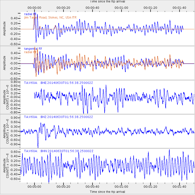
V60A Jim Taylor Road, Stokes, NC, USA - Earthquake Result Viewer
*The percent match for this event was below the threshold and hence no stack was calculated.
| Earthquake location: |
North Of Ascension Island |
| Earthquake latitude/longitude: |
0.0/-17.3 |
| Earthquake time(UTC): |
2014/06/30 (181) 01:46:23 GMT |
| Earthquake Depth: |
8.0 km |
| Earthquake Magnitude: |
5.8 MB |
| Earthquake Catalog/Contributor: |
NEIC PDE/NEIC COMCAT |
|
| Network: |
TA USArray Transportable Network (new EarthScope stations) |
| Station: |
V60A Jim Taylor Road, Stokes, NC, USA |
| Lat/Lon: |
35.76 N/77.26 W |
| Elevation: |
8.0 m |
|
| Distance: |
65.9 deg |
| Az: |
309.572 deg |
| Baz: |
108.594 deg |
| Ray Param: |
$rayparam |
*The percent match for this event was below the threshold and hence was not used in the summary stack. |
|
| Radial Match: |
67.449486 % |
| Radial Bump: |
400 |
| Transverse Match: |
56.199104 % |
| Transverse Bump: |
400 |
| SOD ConfigId: |
751272 |
| Insert Time: |
2014-07-14 02:40:21.802 +0000 |
| GWidth: |
2.5 |
| Max Bumps: |
400 |
| Tol: |
0.001 |
|
Signal To Noise
| Channel | StoN | STA | LTA |
| TA:V60A: :BHZ:20140630T01:56:38.250002Z | 4.854476 | 3.5529953E-7 | 7.3190094E-8 |
| TA:V60A: :BHN:20140630T01:56:38.250002Z | 1.3445019 | 2.7899782E-7 | 2.0751017E-7 |
| TA:V60A: :BHE:20140630T01:56:38.250002Z | 2.1904964 | 3.6044287E-7 | 1.6454848E-7 |
| Arrivals |
| Ps | |
| PpPs | |
| PsPs/PpSs | |


