You are here: Home > Network List > TA - USArray Transportable Network (new EarthScope stations) Stations List
> Station X43A Marvell, AR, USA > Earthquake Result Viewer
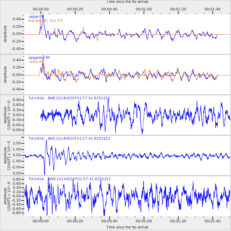
X43A Marvell, AR, USA - Earthquake Result Viewer
*The percent match for this event was below the threshold and hence no stack was calculated.
| Earthquake location: |
North Of Ascension Island |
| Earthquake latitude/longitude: |
0.0/-17.3 |
| Earthquake time(UTC): |
2014/06/30 (181) 01:46:23 GMT |
| Earthquake Depth: |
8.0 km |
| Earthquake Magnitude: |
5.8 MB |
| Earthquake Catalog/Contributor: |
NEIC PDE/NEIC COMCAT |
|
| Network: |
TA USArray Transportable Network (new EarthScope stations) |
| Station: |
X43A Marvell, AR, USA |
| Lat/Lon: |
34.52 N/90.88 W |
| Elevation: |
53 m |
|
| Distance: |
76.4 deg |
| Az: |
305.456 deg |
| Baz: |
99.432 deg |
| Ray Param: |
$rayparam |
*The percent match for this event was below the threshold and hence was not used in the summary stack. |
|
| Radial Match: |
57.274086 % |
| Radial Bump: |
400 |
| Transverse Match: |
62.935925 % |
| Transverse Bump: |
400 |
| SOD ConfigId: |
751272 |
| Insert Time: |
2014-07-14 02:41:09.290 +0000 |
| GWidth: |
2.5 |
| Max Bumps: |
400 |
| Tol: |
0.001 |
|
Signal To Noise
| Channel | StoN | STA | LTA |
| TA:X43A: :BHZ:20140630T01:57:41.825015Z | 7.4949007 | 1.1507251E-6 | 1.535344E-7 |
| TA:X43A: :BHN:20140630T01:57:41.825015Z | 1.6153892 | 4.0911965E-7 | 2.5326383E-7 |
| TA:X43A: :BHE:20140630T01:57:41.825015Z | 1.3825014 | 3.3820425E-7 | 2.446321E-7 |
| Arrivals |
| Ps | |
| PpPs | |
| PsPs/PpSs | |


