You are here: Home > Network List > TA - USArray Transportable Network (new EarthScope stations) Stations List
> Station 121A Cookes Peak, Deming, NM, USA > Earthquake Result Viewer
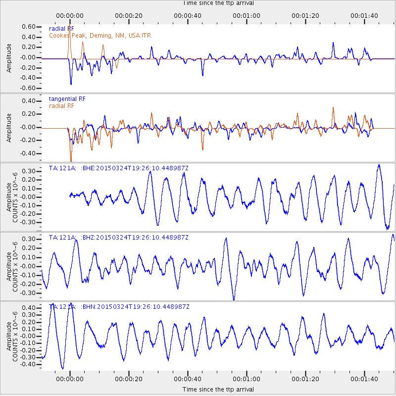
121A Cookes Peak, Deming, NM, USA - Earthquake Result Viewer
*The percent match for this event was below the threshold and hence no stack was calculated.
| Earthquake location: |
Panama |
| Earthquake latitude/longitude: |
7.6/-81.9 |
| Earthquake time(UTC): |
2015/03/24 (083) 19:19:52 GMT |
| Earthquake Depth: |
8.7 km |
| Earthquake Magnitude: |
5.1 MW, 4.8 mb, 4.3 MS |
| Earthquake Catalog/Contributor: |
ISC/ISC |
|
| Network: |
TA USArray Transportable Network (new EarthScope stations) |
| Station: |
121A Cookes Peak, Deming, NM, USA |
| Lat/Lon: |
32.53 N/107.79 W |
| Elevation: |
1652 m |
|
| Distance: |
34.6 deg |
| Az: |
319.402 deg |
| Baz: |
130.209 deg |
| Ray Param: |
$rayparam |
*The percent match for this event was below the threshold and hence was not used in the summary stack. |
|
| Radial Match: |
54.859917 % |
| Radial Bump: |
400 |
| Transverse Match: |
50.72804 % |
| Transverse Bump: |
400 |
| SOD ConfigId: |
7422571 |
| Insert Time: |
2019-04-17 21:47:24.417 +0000 |
| GWidth: |
2.5 |
| Max Bumps: |
400 |
| Tol: |
0.001 |
|
Signal To Noise
| Channel | StoN | STA | LTA |
| TA:121A: :BHZ:20150324T19:26:10.448987Z | 1.1115798 | 1.7946437E-7 | 1.6144982E-7 |
| TA:121A: :BHN:20150324T19:26:10.448987Z | 1.655832 | 2.890751E-7 | 1.7457998E-7 |
| TA:121A: :BHE:20150324T19:26:10.448987Z | 3.222251 | 1.9224159E-7 | 5.966065E-8 |
| Arrivals |
| Ps | |
| PpPs | |
| PsPs/PpSs | |


